 Filter: Categories of Wisconsin Historical Images
Filter: FORMAT_TYPE of prints, photomechanical
Filter: Subject of buildings
Filter: Subject of dams
Filter: Categories of Wisconsin Historical Images
Filter: FORMAT_TYPE of prints, photomechanical
Filter: Subject of buildings
Filter: Subject of dams
| Date: | 1905 |
|---|---|
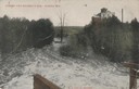
| Description: | View from dam looking down river. A large building is in the background. Caption reads: "Looking Over Brummer's Dam, Algoma, Wis." |
| Date: | 1915 |
|---|---|
| Description: | Elevated view of dam on river. A bridge is in the background. Houses are on top of the hill on the right side. Caption reads: "The Dam, Milwaukee River." |

| Date: | 1920 |
|---|---|
| Description: | Elevated view of dam with a bridge further up the river. Buildings are along the shoreline and on top of the hill on the right. Caption reads: "Scene Above... |
| Date: | |
|---|---|
| Description: | View across the lower dam and bridges near the far shoreline along the Fox River. A tall building is in the background on the right. Caption reads: "The Lo... |
| Date: | |
|---|---|
| Description: | View across the lower dam on the Fox River. Bridges are near the far shoreline, and a tall building is in the distance on the right. Caption reads: "Lower ... |

| Date: | 1873 |
|---|---|
| Description: | Engraved image of a lock and dam at Sault St. Marie. Two men are operating the sluice as ships are waiting on the opposite side of the lock. Another man is... |

| Date: | |
|---|---|
| Description: | This map shows the township and range system, sections, dam locations, railroads, roads, selected buildings, and lakes and streams in Sawyer County, Wiscon... |

| Date: | 02 1956 |
|---|---|
| Description: | This 1956 map of Waukesha County, Wisconsin, shows the township and range grid, towns, sections, cities and villages, roads, railroads, dams, airports, par... |
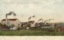
| Date: | |
|---|---|
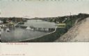
| Description: | View of three factories; Upper Woolen Mill, Empire Rolling Mill, and Mallable Iron Co. Caption reads: "Some of the Manufacturing Industries of Beaver Dam." |

| Date: | 1910 |
|---|---|
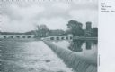
| Description: | View across top of the Pecatonica River dam towards the opposite shoreline. Caption reads: "The Dam at Darlington, Wis." |
| Date: | 1910 |
|---|---|
| Description: | Colored postcard view of the old mill, stream and a dam. Caption reads: "Old Mill and Race, Near Milwaukee, Wis. At Delafield." |
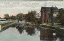
| Date: | 1910 |
|---|---|
| Description: | Color postcard view from shoreline looking towards of the dam on the Crawfish River. Buildings are on the opposite shoreline. Caption reads: "Night Scene a... |
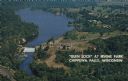
| Date: | 1950 |
|---|---|
| Description: | Color postcard aerial view. Caption reads: "'Glen Lock' at Irvine Park, Chippewa Falls, Wisconsin." Caption on back reads: "This view from Irvine Park show... |

| Date: | 1910 |
|---|---|
| Description: | This blue print map shows original lakes, area to be covered by Chippewa Flowage (flow-lines for contours 1310 and 1315), dam sites, roads, and buildings. |

| Date: | 1907 |
|---|---|
| Description: | Color illustration of a bridge over a dam on the Rock River. Caption reads: "Rock River Wagon Bridge and Dam, at Monteray, Janesville, Wis." |

| Date: | 1912 |
|---|---|
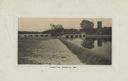
| Description: | A group of boys are fishing on the river bank beside a dam. Buildings are on the far bank. Caption reads: "Fishing at Dam on Rock River, Jefferson, Wis." |
| Date: | 1909 |
|---|---|
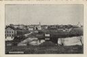
| Description: | View of Kekoskee from across the Rock River. Caption reads: "Kekoskee, Wis." |

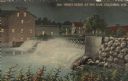
| Date: | 1908 |
|---|---|
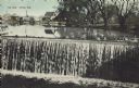
| Description: | Dam on the Red Cedar River. Caption reads: "Red Cedar Dam, Menomonie, Wis." |
| Date: | 1907 |
|---|---|
| Description: | Text on front reads: "The Dam, Ripon, Wis." Water spills over the Ripon Dam, on Silver Creek, with the Ripon Pond in the background. Dwellings and a buildi... |

| Date: | 11 28 1908 |
|---|---|
| Description: | Text on front reads: "High Bridge, Baraboo, Wis." A truss bridge over the Baraboo River with a spillway underneath. The shorelines are wooded and buildings... |
If you didn't find the material you searched for, our Library Reference Staff can help.
Call our reference desk at 608-264-6535 or email us at: