Filter: Categories of Wisconsin Historical Images
Filter: FORMAT_TYPE of prints, photomechanical
Filter: Subject of buildings
Filter: Subject of land
Filter: Categories of Wisconsin Historical Images
Filter: FORMAT_TYPE of prints, photomechanical
Filter: Subject of buildings
Filter: Subject of land
| Date: | |
|---|---|
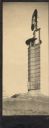
| Description: | The Romeo and Juliet windmill outside of Hillside Home School, an early progressive school operated by Ellen and Jane Lloyd Jones, aunts of the Frank Lloyd... |

| Date: | 1910 |
|---|---|
| Description: | View from road toward Mineral Springs. There is a board sidewalk in the foreground. Caption reads: "Mineral Sprints, Green Bay, Wis." |
| Date: | 1900 |
|---|---|
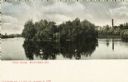
| Description: | View across water towards Tivoli Island. There is a smokestack and a building among trees in the distance. Caption reads: "Tivoli Island, Watertown, Wis." |

| Date: | 1900 |
|---|---|
| Description: | A group of immigrants, both children and adults, who have just arrived at Ellis Island. |

| Date: | 1913 |
|---|---|
| Description: | Rocky Roost, a cottage, which was located west of Governor's Island in Lake Mendota. The cottage was designed and built in 1893 (according to Taliesin Asso... |
| Date: | 1908 |
|---|---|
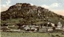
| Description: | A dirt drive in the park, in between some hills, with a bridge in the background leading to a building on the right. Next to the path are a stack of pipes... |
| Date: | 1915 |
|---|---|
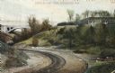
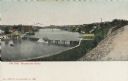
| Description: | Elevated view of dam on river. A bridge is in the background. Houses are on top of the hill on the right side. Caption reads: "The Dam, Milwaukee River." |
| Date: | |
|---|---|
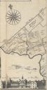
| Description: | A detail of Philadelphia, including Mills Creek, Alms House and land ownership designations. |
| Date: | 1947 |
|---|---|
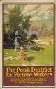
| Description: | An original colored lithograph advertising the London Midland and Scottish Railway Company, and promoting Haddon Hall and the Wye Valley as "The Peak Distr... |
| Date: | 1933 |
|---|---|
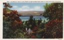
| Description: | Colorized postcard of Devil's Lake and bluffs seen through the trees. Some of the trees have autumn color. A roof and chimney are visible. The text at the ... |

| Date: | 1914 |
|---|---|
| Description: | Colorized postcard of the rock formation called the Devil's Doorway in Devil's Lake State Park. Trees can be seen below. The lake, bluffs, roads and buildi... |

| Date: | 1861 |
|---|---|
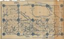
| Description: | Shows townships and sections, landowners, and woodlands. Includes inset maps of Monroe, Brodhead, Albany, Cadiz, Decatur, Dayton, Clarence, Springfield, Tw... |

| Date: | 1879 |
|---|---|
| Description: | A map of Jackson County, Wisconsin, shows the township and section survey, landownership, towns, villages, buildings, roads, railroads, county land, and st... |

| Date: | 1858 |
|---|---|
| Description: | This 1858 map of Racine County, Wisconsin, shows land ownership and acreages, the township and range grid, towns, cities and villages, roads, railroads, sc... |

| Date: | 1934 |
|---|---|
| Description: | This 1934 map of Racine County, Wisconsin, shows the township and range grid, cities and villages, vegetation type, land use, roads, railroads, utilities, ... |

| Date: | 1876 |
|---|---|
| Description: | This 1876 map of Saint Croix County, Wisconsin, shows the township and range grid, sections, towns, cities and villages, land ownership and acreages, wagon... |

| Date: | 1877 |
|---|---|
| Description: | This 1877 map of Sauk County, Wisconsin, shows the township and range grid, sections, towns, cities and villages, land ownership and acreages, wagon roads,... |

| Date: | 1919 |
|---|---|
| Description: | "Map showing the main travelled State and Federal Highways upon which the County Board proposes to expend $1,200,000 for permanent improvements, if you wil... |
| Date: | 1927 |
|---|---|
| Description: | Shows section corners, landownership and acreages, roads, railroad, Weston village, and buildings of W.J. Starr Estate. Relief shown by hachures. "Map comp... |
If you didn't find the material you searched for, our Library Reference Staff can help.
Call our reference desk at 608-264-6535 or email us at: