 Filter: Categories of Wisconsin Historical Images
Filter: FORMAT_TYPE of prints, photomechanical
Filter: Subject of buildings
Filter: Subject of land use
Filter: Categories of Wisconsin Historical Images
Filter: FORMAT_TYPE of prints, photomechanical
Filter: Subject of buildings
Filter: Subject of land use
| Date: | |
|---|---|
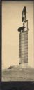
| Description: | The Romeo and Juliet windmill outside of Hillside Home School, an early progressive school operated by Ellen and Jane Lloyd Jones, aunts of the Frank Lloyd... |
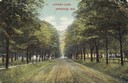
| Date: | 1909 |
|---|---|
| Description: | View down Lover's Lane. Caption reads: "Lover's Lane, Appleton, Wis." |
| Date: | 1910 |
|---|---|
| Description: | Street scene in Ellison Bay. On the far left is a building with a bell tower on the roof. Caption reads: "St. Scene, Ellison Bay, Wis." |
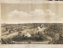
| Date: | 1859 |
|---|---|
| Description: | Elevated view of the fairgrounds in Milwaukee, the year when Abraham Lincoln spoke. The fairgrounds were located at the Brockway Grounds near Twelfth and S... |
| Date: | 1905 |
|---|---|
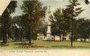
| Description: | View across lawn towards the Monument. A building is in the background. Caption reads: "Soldiers Monument, Janesville, Wis." |
| Date: | 1915 |
|---|---|
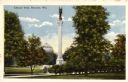
| Description: | View of park with monument on lawn. A domed building is in the background. Caption reads: "Library Park, Kenosha, Wis." |

| Date: | 1908 |
|---|---|
| Description: | Exterior view of the hall. Caption reads: "Bertha Tainter Hall, Menomonie, Wis." |
| Date: | 1900 |
|---|---|
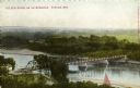
| Description: | Elevated view of a bridge over the Wisconsin River. Caption reads: "The New Bridge on the Wisconsin, Portage, Wis." |
| Date: | 1900 |
|---|---|
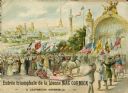
| Description: | Color lithograph cover illustration of the French edition of a McCormick catalog, showing a man driving a McCormick reaper through a parade at the 1900 Wor... |
| Date: | |
|---|---|
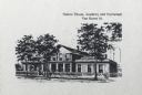
| Description: | Caption reads: "Sisters' House, Academy and Orphanage Van Buren St." Three trees stand in front of the building. A woman is in front left of center, and tw... |

| Date: | 1858 |
|---|---|
| Description: | This 1858 map of Racine County, Wisconsin, shows land ownership and acreages, the township and range grid, towns, cities and villages, roads, railroads, sc... |

| Date: | 1876 |
|---|---|
| Description: | This 1876 map of Saint Croix County, Wisconsin, shows the township and range grid, sections, towns, cities and villages, land ownership and acreages, wagon... |

| Date: | 1877 |
|---|---|
| Description: | This 1877 map of Sauk County, Wisconsin, shows the township and range grid, sections, towns, cities and villages, land ownership and acreages, wagon roads,... |

| Date: | 1862 |
|---|---|
| Description: | This map shows townships and sections, landownership and acreages, roads, railroads, cemeteries, churches, schools, mills, and stone quarries. "Engraved, p... |

| Date: | 1876 |
|---|---|
| Description: | Map shows townships and sections, landownership and acreages, roads, railroads, post offices, and farms. Sections appear in pink, yellow, and blue. On the ... |
| Date: | |
|---|---|
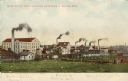
| Description: | View of three factories; Upper Woolen Mill, Empire Rolling Mill, and Mallable Iron Co. Caption reads: "Some of the Manufacturing Industries of Beaver Dam." |

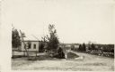
| Date: | 1907 |
|---|---|
| Description: | Photographic postcard view of a building housing a store and post office, surrounded by trees next to a lake. Captions read: "Boe's Store and Post Office, ... |
| Date: | |
|---|---|
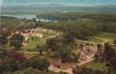
| Description: | Color postcard of an elevated view of Stonefield Village with the Mississippi River in the background and railroad tracks in the foreground. |
| Date: | |
|---|---|
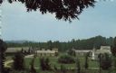
| Description: | Elevated color postcard view of Stonefield Village from across the churchyard. |
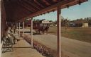
| Date: | 1973 |
|---|---|
| Description: | Color postcard of Main Street from porch on building at Stonefield Village. A horse bus with tourists is in the street. |
If you didn't find the material you searched for, our Library Reference Staff can help.
Call our reference desk at 608-264-6535 or email us at: