 Filter: Categories of Wisconsin Historical Images
Filter: FORMAT_TYPE of prints, photomechanical
Filter: Subject of buildings
Filter: Subject of michigan, lake
Filter: Categories of Wisconsin Historical Images
Filter: FORMAT_TYPE of prints, photomechanical
Filter: Subject of buildings
Filter: Subject of michigan, lake

| Date: | 1932 |
|---|---|
| Description: | View of Lake Michigan from Memorial Hall. Caption reads: "Lake Michigan from Memorial Hall, Racine, Wisconsin". |

| Date: | 1910 |
|---|---|
| Description: | Elevated view over trees and bushes toward the footbridge. A building with a red roof is on the far right. Beyond the bridge is Lake Michigan. Caption read... |

| Date: | 1934 |
|---|---|
| Description: | This 1934 map of Racine County, Wisconsin, shows the township and range grid, cities and villages, vegetation type, land use, roads, railroads, utilities, ... |

| Date: | 1891 |
|---|---|
| Description: | This maps has an index of depots, hotels, prominent institutions and buildings, churches, and places of amusement. The map was removed from an unidentified... |

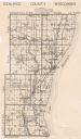
| Date: | 1886 |
|---|---|
| Description: | Map shows townships, post offices, roads, railroads, and selected buildings. The sections are in pink, green, blue, and yellow. Counties, towns, and lakes ... |
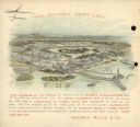
| Date: | 1892 |
|---|---|
| Description: | Back cover of calendar, with the text: "Hail Columbia, Happy Land!" Features a bird's-eye illustration of the 1893 World's Columbian Exposition (World's Fa... |

| Date: | 1857 |
|---|---|
| Description: | This map shows land ownership by name, local streets, wards, buildings, parks, a cemetery, and part of Lake Michigan. Depths are shown by soundings and nor... |

| Date: | 1893 |
|---|---|
| Description: | This map shows city wards, block numbers, parks, cemeteries, roads, railroads, selected buildings, and Lake Michigan. Also included are indexes to streets,... |

| Date: | 1900 |
|---|---|
| Description: | This map shows city wards, block numbers, parks, cemeteries, roads, railroads, Lake Michigan, and selected buildings. Also included are indexes "Milwaukee ... |

| Date: | 1901 |
|---|---|
| Description: | This map shows city wards, block numbers, parks, cemeteries, roads, railroads, Lake Michigan, and selected buildings. Also included are indexes "Milwaukee ... |

| Date: | 1920 |
|---|---|
| Description: | This map shows wards, streets, railroads, parks, cemeteries, select buildings, and Lake Michigan. Also included is a street index. Cemeteries and parks are... |

| Date: | 1926 |
|---|---|
| Description: | This blueprint map shows the land and its uses near Two Rivers Harbor. Lake Michigan is labeled on the left. Roads and buildings are also labeled. Original... |

| Date: | 1894 |
|---|---|
| Description: | This map shows railroads, street railways, ward lines, land parcels, streets, schools and public buildings. Ward lines are highlighted in red. Lake Michiga... |

| Date: | 1926 |
|---|---|
| Description: | This blueprint map shows the harbor at Kenosha, also showing buildings surrounding the harbor, roads, and railroads. Original caption in red states: "Areas... |
| Date: | 1913 |
|---|---|
| Description: | This map shows landownership, rural mail routes, rural buildings, railroads, U.S. national highways, state trunk highways, county trunk highways, township... |
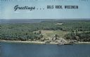
| Date: | |
|---|---|
| Description: | A color aerial view of Gills Rock from Green Bay. Washington Island and Lake Michigan are along the horizon. An excursion boat is docked at the landing. Ca... |
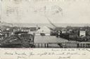
| Date: | 1905 |
|---|---|
| Description: | Elevated view over the Manitowoc River where it meets Lake Michigan. Downtown Manitowoc is on both sides, and people are on bridges crossing over the river... |

| Date: | |
|---|---|
| Description: | Photographic postcard view across water towards the Coast Guard Station on Lake Michigan. Cutters are moored next to a sea wall. Caption reads: "Coast Guar... |
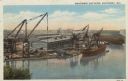
| Date: | 1939 |
|---|---|
| Description: | Elevated view of the Manitowoc shipyards on Lake Michigan. Two ships are being built. Caption reads: "Manitowoc Shipyards, Manitowoc, Wis." |

| Date: | |
|---|---|
| Description: | View across water towards a lighthouse and adjoining building at the end of a wharf. A boat is on the lake in the foreground. Caption reads: "The Light Hou... |
If you didn't find the material you searched for, our Library Reference Staff can help.
Call our reference desk at 608-264-6535 or email us at: