 Filter: Categories of Wisconsin Historical Images
Filter: FORMAT_TYPE of prints, photomechanical
Filter: Subject of buildings
Filter: Subject of roads
Filter: Categories of Wisconsin Historical Images
Filter: FORMAT_TYPE of prints, photomechanical
Filter: Subject of buildings
Filter: Subject of roads
| Date: | 1910 |
|---|---|
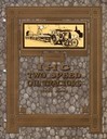
| Description: | Cover of an advertising catalog for IHC Type A and Type B two speed oil tractors. |
| Date: | 1909 |
|---|---|
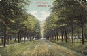
| Description: | View down Lover's Lane. Caption reads: "Lover's Lane, Appleton, Wis." |

| Date: | 1920 |
|---|---|
| Description: | Caption reads: "Mammoth Ore Docks, Ashland, Wis." A building and roads are in the foreground. Several ore ships can be seen. |

| Date: | 1910 |
|---|---|
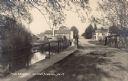
| Description: | View from road toward Mineral Springs. There is a board sidewalk in the foreground. Caption reads: "Mineral Sprints, Green Bay, Wis." |
| Date: | 1914 |
|---|---|
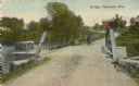
| Description: | View of a bridge with several buildings in the background. Caption reads: "'The Bridge' Honey Creek, Wis." |
| Date: | 1859 |
|---|---|
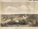
| Description: | Elevated view of the fairgrounds in Milwaukee, the year when Abraham Lincoln spoke. The fairgrounds were located at the Brockway Grounds near Twelfth and S... |
| Date: | |
|---|---|
| Description: | View down Crawfish Bridge, with a horse-drawn buggy approaching the bridge. Buildings and trees are along the river on the right. Caption reads: "View from... |
| Date: | |
|---|---|
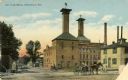
| Description: | Horse-drawn vehicles and pedestrians are in the street. Caption reads: "Cady Street. Watertown, Wisconsin. |
| Date: | 1911 |
|---|---|
| Description: | Man and dog standing near bridge. Buildings in background. There is a boat on the left on the water near the bridge. Caption reads: "Bridge, Okauchee, Wis.... |
| Date: | 1908 |
|---|---|
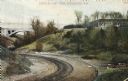
| Description: | A dirt drive in the park, in between some hills, with a bridge in the background leading to a building on the right. Next to the path are a stack of pipes... |

| Date: | 1920 |
|---|---|
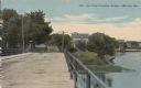
| Description: | Elevated view of the building on a street corner, with a flag flying from the roof. The street has parked cars and pedestrians are on the sidewalks. Captio... |

| Date: | 1914 |
|---|---|
| Description: | Colorized postcard of the rock formation called the Devil's Doorway in Devil's Lake State Park. Trees can be seen below. The lake, bluffs, roads and buildi... |

| Date: | 1861 |
|---|---|
| Description: | Shows townships and sections, landowners, and woodlands. Includes inset maps of Monroe, Brodhead, Albany, Cadiz, Decatur, Dayton, Clarence, Springfield, Tw... |
| Date: | |
|---|---|
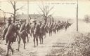
| Description: | Postcard printed in brown ink of a line of soldiers in uniform hiking in a column. They have bedrolls over their shoulders. Towards the rear are soldiers o... |

| Date: | 1868 |
|---|---|
| Description: | A detailed, cloth mounted map of Grant County that shows the townships, towns, roads, completed and under construction railroads, cemeteries, mills, lead m... |

| Date: | 1879 |
|---|---|
| Description: | A map of Jackson County, Wisconsin, shows the township and section survey, landownership, towns, villages, buildings, roads, railroads, county land, and st... |

| Date: | 1858 |
|---|---|
| Description: | This 1858 map of Racine County, Wisconsin, shows land ownership and acreages, the township and range grid, towns, cities and villages, roads, railroads, sc... |

| Date: | 1934 |
|---|---|
| Description: | This 1934 map of Racine County, Wisconsin, shows the township and range grid, cities and villages, vegetation type, land use, roads, railroads, utilities, ... |

| Date: | 1876 |
|---|---|
| Description: | This 1876 map of Saint Croix County, Wisconsin, shows the township and range grid, sections, towns, cities and villages, land ownership and acreages, wagon... |

| Date: | 1877 |
|---|---|
| Description: | This 1877 map of Sauk County, Wisconsin, shows the township and range grid, sections, towns, cities and villages, land ownership and acreages, wagon roads,... |
If you didn't find the material you searched for, our Library Reference Staff can help.
Call our reference desk at 608-264-6535 or email us at: