 Filter: Categories of Wisconsin Historical Images
Filter: FORMAT_TYPE of prints, photomechanical
Filter: Subject of cemeteries
Filter: Categories of Wisconsin Historical Images
Filter: FORMAT_TYPE of prints, photomechanical
Filter: Subject of cemeteries

| Date: | 1881 |
|---|---|
| Description: | Bird's-eye map of Milton Junction. |

| Date: | 1867 |
|---|---|
| Description: | Drawn map showing planned development of Cornell, including a couple of schools, Oakwood cemetery, the public square, and several bridges and dams. |
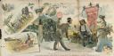
| Date: | 1890 |
|---|---|
| Description: | Advertising poster for Champion brand agricultural machines, manufactured by Warder, Bushnell and Glessner Company. The main illustration depicts a salesma... |

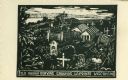
| Date: | 1909 |
|---|---|
| Description: | Caption reads: "Main Entrance — Hillside Cemetery, Lancaster, Wis." |
| Date: | 1959 |
|---|---|
| Description: | Caption reads: "Old Indian Burying Grounds LaPointe Wisconsin." |

| Date: | 1905 |
|---|---|
| Description: | Indian cemetery. A large body of water is in the background. Caption reads: "Indian Burying Grounds, Bayfield, Wis." |

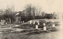
| Date: | 1904 |
|---|---|
| Description: | Graves of Joseph Rolette and his daughter, Elizabeth. Rolette died in 1842. The cemetery itself may date as early as the middle of the 17th Century. |
| Date: | 1905 |
|---|---|
| Description: | Fort Crawford Military Cemetery, after restoration by the United States Government. In the left background is the Prairie du Chien Sanitarium, built on the... |

| Date: | 1898 |
|---|---|
| Description: | "Confederate Rest" in Forest Hill Cemetery where Confederate prisoners of war who died at Camp Randall are buried. In this early photograph, there is a woo... |
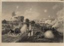
| Date: | |
|---|---|
| Description: | Engraving excerpted from John S.C. Abbott's History of the Civil War in America. |

| Date: | 1913 |
|---|---|
| Description: | A wall atlas of Sauk County, Wisconsin, displaying its 22 towns. On the left side are advertisements for local businesses. |
| Date: | |
|---|---|
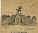
| Description: | Drawing of a monument to General Albert Sydney Johnston, which was erected by Association of the Army of Tennessee in the St. Louis Cemetery in New Orleans... |

| Date: | 1914 |
|---|---|
| Description: | Plat book of Waukesha County. Pages 14 - 15. |
| Date: | |
|---|---|
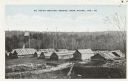
| Description: | Native American burial ground. Caption reads: "An Indian Burying Ground, Near Antigo, Wis." |

| Date: | 1972 |
|---|---|
| Description: | This map on 5 sheets features a title page sheet with business directory and shows section numbers, roads, railroads, saw mills, churches, blacksmith shops... |
| Date: | |
|---|---|
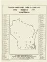
| Description: | A map of Wisconsin showing the gravesite locations of the 43 Revolutionary War soldiers buried in state, surrounding the map are the names and in some inst... |
| Date: | |
|---|---|
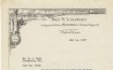
| Description: | Letterhead of Fred M. Schlimgen of Madison, Wisconsin, designer and builder of memorial markers, with a landscape of classical buildings, a cloud-filled sk... |
| Date: | |
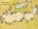
|---|---|
| Description: | A color, pictorial map that shows sites related to Native American villages, sites, cemeteries in the area around the lakes Geneva and Como in Walworth Cou... |

| Date: | 1868 |
|---|---|
| Description: | A detailed, cloth mounted map of Grant County that shows the townships, towns, roads, completed and under construction railroads, cemeteries, mills, lead m... |

| Date: | |
|---|---|
| Description: | A map of Grant County, Wisconsin showing the locations of townships, towns, cities, villages, roads, railroads, schools, cemeteries, churches, rivers, and ... |
If you didn't find the material you searched for, our Library Reference Staff can help.
Call our reference desk at 608-264-6535 or email us at: