 Filter: Categories of Wisconsin Historical Images
Filter: FORMAT_TYPE of prints, photomechanical
Filter: Subject of cities and towns
Filter: Subject of civil war, 1861-1865
Filter: Categories of Wisconsin Historical Images
Filter: FORMAT_TYPE of prints, photomechanical
Filter: Subject of cities and towns
Filter: Subject of civil war, 1861-1865

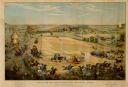
| Date: | 1862 |
|---|---|
| Description: | Camp Randall looking southwest. In April 1861, Governor Alexander Randall asked that the State Agricultural Society fairgrounds be converted into a militar... |
| Date: | 1886 |
|---|---|
| Description: | Color lithographed color advertising poster showing a McCormick grain binder at the Civil War battle of Gettysburg. The poster was based on a cyclorama by ... |
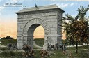
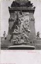
| Date: | 1912 |
|---|---|
| Description: | Camp Randall Memorial Arch and Civil War cannons. The memorial was built to honor Wisconsin Civil War soldiers and is located on the University of Wisconsi... |
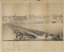
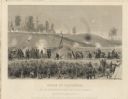
| Date: | 09 22 1862 |
|---|---|
| Description: | The 22nd Regiment Wisconsin Volunteers under the command of Colonel William L. Utley, crossing the pontoon bridge at Cincinnati. |

| Date: | 1909 |
|---|---|
| Description: | A Civil War Monument and fountain in Lancaster. Caption reads: "Fountain in Honor of the Boys in Blue, Lancaster, Wis." |
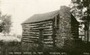
| Date: | 1920 |
|---|---|
| Description: | A view of the cabin on the property of the Milton House, which was a part of the Underground Railroad prior to the abolition of slavery. The house was buil... |
| Date: | 1886 |
|---|---|
| Description: | Lithographed advertising poster showing a McCormick grain binder at the Civil War battle of Gettysburg. The poster was based on a cyclorama by French artis... |

| Date: | 1898 |
|---|---|
| Description: | "Confederate Rest" in Forest Hill Cemetery where Confederate prisoners of war who died at Camp Randall are buried. In this early photograph, there is a woo... |
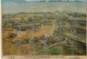
| Date: | 1864 |
|---|---|
| Description: | "Siege of Vicksburg." An etching published by Johnson, Fry & Company from a painting by Chappel of the Union lines during the battle. |
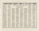
| Date: | |
|---|---|
| Description: | A poster with a list of names of Civil War soldiers arranged by military unit. |

| Date: | 1861 |
|---|---|
| Description: | A hand-drawn poster, produced by S.W. Martin's Writing Academy of Madison, listing the officers and men of the 1st Regiment, Wisconsin Volunteer Infantry, ... |
| Date: | 1910 |
|---|---|
| Description: | View of the monument. Caption reads: "Peace Tablet, Soldier's and Sailor's Monument, Indianapolis." |

| Date: | |
|---|---|
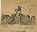
| Description: | Color postcard featuring an equestrian statue of Confederate General Robert E. Lee. Caption reads: "Lee Monument and Monument Avenue. Richmond, VA." |
| Date: | |
|---|---|
| Description: | Drawing of a monument to General Albert Sydney Johnston, which was erected by Association of the Army of Tennessee in the St. Louis Cemetery in New Orleans... |
| Date: | |
|---|---|
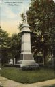
| Description: | A colored postcard view of a Union memorial Caption reads: " Soldiers' Monument, Tiffin, Ohio." |

| Date: | 1861 |
|---|---|
| Description: | A general map of Pennsylvania, Virginia, New Jersey and Delaware. Insets include maps of New Orleans, Baltimore, St. Louis, Charleston, Savannah, Washingto... |

| Date: | 1864 |
|---|---|
| Description: | (U.S. 39th Cong. 1stt Sess. Report of Chief engineer) The legend in the upper left corner contains a brief resume of each day's action while the map sho... |
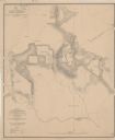
| Date: | 1864 |
|---|---|
| Description: | This map depicts the battlefield at Todd's Tavern, Va., the site of a battle on May 7-8, 1864. Depicted are roads, houses, drainage, vegetation and troop p... |

| Date: | 1864 |
|---|---|
| Description: | This map of the Battle of Gettysburg indicates Union positions in red and Confederate positions in blue. Also shown are artillery positions, roads, railroa... |
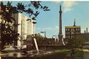
| Date: | 1975 |
|---|---|
| Description: | Photographic postcard view of Monument Square looking south. In the bottom right corner, a man sits on a bench looking at the fountain. The Civil War Soldi... |
If you didn't find the material you searched for, our Library Reference Staff can help.
Call our reference desk at 608-264-6535 or email us at: