 Filter: Categories of Wisconsin Historical Images
Filter: FORMAT_TYPE of prints, photomechanical
Filter: Subject of cities and towns
Filter: Subject of floods
Filter: Categories of Wisconsin Historical Images
Filter: FORMAT_TYPE of prints, photomechanical
Filter: Subject of cities and towns
Filter: Subject of floods

| Date: | 1926 |
|---|---|
| Description: | This hand-colored blueprint map shows landowners in part of T15N, R5E in Juneau County. North is oriented to the right. |
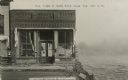
| Date: | 10 06 1911 |
|---|---|
| Description: | View of Monsos Brothers Grocery & Crockery after most of the building was washed away by the flooding Black River. High, rushing water can be seen on the r... |
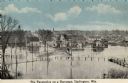
| Date: | 1910 |
|---|---|
| Description: | Elevated view of the Pecatonica River at the bridge. The river is flooding the town. Caption reads: "Pecatonica River on a Rampage, Darlington, , Wis." |
If you didn't find the material you searched for, our Library Reference Staff can help.
Call our reference desk at 608-264-6535 or email us at: