Filter: Categories of Wisconsin Historical Images
Filter: FORMAT_TYPE of prints, photomechanical
Filter: Subject of cities and towns
Filter: Subject of flour mills
Filter: Categories of Wisconsin Historical Images
Filter: FORMAT_TYPE of prints, photomechanical
Filter: Subject of cities and towns
Filter: Subject of flour mills
| Date: | |
|---|---|
| Description: | View of the flouring and carding mills of J.A. Briggs. Caption at botto reads: "Flouring and Carding Mills of J. A. Briggs Village of Briggsville Marqette ... |
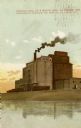
| Date: | 1905 |
|---|---|
| Description: | View across water toward the flour mill at Listman Mill Company. Caption reads: "Listman Mill Co.'s Flour Mill, La Crosse, Wis." |

| Date: | 1920 |
|---|---|
| Description: | View across water toward the Mississippi River front showing Listman's Mills. Caption reads: "River Front and Listman's Mills, La Crosse, Wis." |

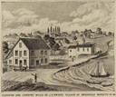
| Date: | 1847 |
|---|---|
| Description: | An artists rendition of the western view of the Thiensville mills from the local tavern. Caption reads: "West View of Thiensville Mills from the Tavern." |
| Date: | 1851 |
|---|---|
| Description: | Engraving of the five-story tall mill erected at the outlet of the Yahara Creek by Leonard J. Farwell. This engraving appears in Statistics of Dane County,... |

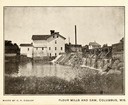
| Date: | 1906 |
|---|---|
| Description: | View of Horlick's mill and dam, also known as "Ye Old Mill." |
| Date: | 1910 |
|---|---|
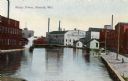
| Description: | Industrial area with view of Kimberly Clark Mill, and other unidentified mills. Caption reads: "Water Power, Neenah, Wis." |

| Date: | |
|---|---|
| Description: | M. Keenan & Company, flour and feed mill. Small print of mill on the water front. River is behind the building with a steamboat and a ship. A tall smoke... |

| Date: | 1871 |
|---|---|
| Description: | This map of Barron County, Wisconsin, shows the township and range grid, towns, sections, cities and villages, post offices, dwellings, schools, roads, swa... |

| Date: | 1858 |
|---|---|
| Description: | Map showing roads, mills, and rivers. Date conjectured from presence of Ensign’s Mill and Pitt’s Mill and location of Nekoosa. |

| Date: | 05 1958 |
|---|---|
| Description: | Photocopy of a map created by the City of Milwaukee Master Plan Program City Planning Division in May of 1958 representing 1870 "THE CENTRAL AREA OF THE CI... |

| Date: | 1885 |
|---|---|
| Description: | A detail of a Sanborn map including Catfish Creek and Westport Road by Lake Mendota. |

| Date: | 1855 |
|---|---|
| Description: | This map is ink, pen, and watercolor on paper and shows plat of the town, local streets, lots by number, U.S. subdivisions in red lines, Mineral Point Rail... |

| Date: | 1851 |
|---|---|
| Description: | This map shows townships, villages, Indian villages, railroads, roads, mills, prairies, swamps, and canals. An inset map shows a plat of the copper distric... |
| Date: | 1912 |
|---|---|
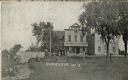
| Description: | View along stream towards people standing in front of buildings and near a stone bridge. The buildings include a post office and a feed mill. Caption reads... |
| Date: | |
|---|---|
| Description: | Elevated view of a street next to the train depot. A train is on the left, and a mill and grain company is in the background. Caption reads: "Railroad St. ... |
| Date: | |
|---|---|
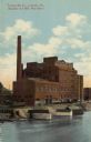
| Description: | Hand-colored view of a flour mill on the Mississippi River. Caption reads: "Listman Mill Co., La Crosse, Wis." Subtitle reads: "(Capacity 6600 Bbls. Flour ... |

| Date: | 1877 |
|---|---|
| Description: | A page from an illustrated historical atlas showing four residences, a hotel and the flouring mill of John Ochsner. |
If you didn't find the material you searched for, our Library Reference Staff can help.
Call our reference desk at 608-264-6535 or email us at: