 Filter: Categories of Wisconsin Historical Images
Filter: FORMAT_TYPE of prints, photomechanical
Filter: Subject of cities and towns
Filter: Subject of law
Filter: Categories of Wisconsin Historical Images
Filter: FORMAT_TYPE of prints, photomechanical
Filter: Subject of cities and towns
Filter: Subject of law

| Date: | 1867 |
|---|---|
| Description: | Bird's-eye map of La Crosse with nine insets of residences, schools, and the Court House and Jail. |

| Date: | 1885 |
|---|---|
| Description: | Bird's-eye map of Waupun on the Rock River. There is an inset at top center of "Althouse, Wheeler & Co., Windmills and Pumps." |
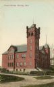
| Date: | 1905 |
|---|---|
| Description: | View across road toward the court house. Caption reads: "Court House, Hurley, Wis." |
| Date: | 1889 |
|---|---|
| Description: | Dane County Courthouse, begun in the fall of 1883 and finished in the spring of 1886. The cost, including equipment, was a little over $180,000. |
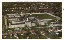
| Date: | 1915 |
|---|---|
| Description: | Aerial view of the Wisconsin State Prison. Caption reads: "Aerial View, Wisconsin State Prison, Waupun, Wis." |
| Date: | 1910 |
|---|---|
| Description: | Exterior view of the county jail in Sturgeon Bay. Caption reads: "New County Jail, Sturgeon Bay, Wis." |
| Date: | 1910 |
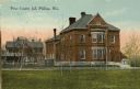
|---|---|
| Description: | View across lawn towards the Price County Jail. Caption reads: "Price County Jail Phillips, Wis." |

| Date: | 1964 |
|---|---|
| Description: | Tom Hayden, in the center wearing the dark shirt, looking at a police officer talking to four African-American men. Newark ERAP project. From the SDS colle... |
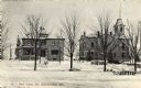
| Date: | |
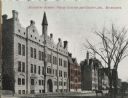
|---|---|
| Description: | View also includes two trees and a horse-drawn carriage. Caption reads: "Broadway Armory, Police Station and County Jail, Milwaukee." |

| Date: | 1905 |
|---|---|
| Description: | Color image of courthouse with a large tree and park on the left. View taken at an angle to the building from across the street. Horse-drawn carriages are ... |

| Date: | 1870 |
|---|---|
| Description: | Slightly elevated view at an angle towards the left and front of the courthouse. A large statue is on top of the main dome. The area around the courthouse ... |
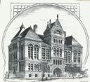
| Date: | 1911 |
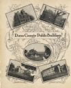
|---|---|
| Description: | A decorative page featuring Dane County public buildings, including a court house, a jail, the poor farm building, and two views of an asylum. |
| Date: | |
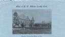
|---|---|
| Description: | Letterhead on blue paper of the Waushara County Clerk's office, with a three-quarter halftone view of the county courthouse and jail and the Waushara Count... |
| Date: | 1900 |
|---|---|
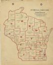
| Description: | A map of Wisconsin showing the seventeen judicial circuits of the state. The map also shows the counties of Wisconsin and the total population of each of t... |
| Date: | 1922 |
|---|---|
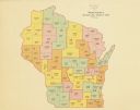
| Description: | A map of Wisconsin showing the state’s judicial districts, it also provides the population total for each county. |

| Date: | 1933 |
|---|---|
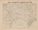
| Description: | A road map of Wisconsin and Michigan’s Upper Peninsula, showing the populations of cities and villages, state and federal highways, national forests, state... |
| Date: | |
|---|---|
| Description: | Map covering most of Georgia and South Carolina, showing defenses along the seacoast and around the principal towns, Confederate prisons at Andersonville a... |

| Date: | 1845 |
|---|---|
| Description: | Wisconsin was considered part of Michigan Territory until 1836, a year before Michigan entered statehood. Drawn three years before Wisconsin entered stateh... |
| Date: | 1898 |
|---|---|
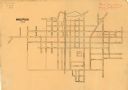
| Description: | This is a map of Waupun in 1898 that shows labeled streets, railroads, and the location of the state prison. There are annotations on the map in what appea... |
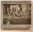
| Date: | 11 22 1963 |
|---|---|
| Description: | Original UPI Wirephoto transmission. Caption reads: "Dallas: President John F. Kennedy is shown in motorcade as it moved toward the downtown area. In cente... |
If you didn't find the material you searched for, our Library Reference Staff can help.
Call our reference desk at 608-264-6535 or email us at: