 Filter: Categories of Wisconsin Historical Images
Filter: FORMAT_TYPE of prints, photomechanical
Filter: Subject of cities and towns
Filter: Subject of lumber
Filter: Categories of Wisconsin Historical Images
Filter: FORMAT_TYPE of prints, photomechanical
Filter: Subject of cities and towns
Filter: Subject of lumber

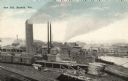
| Date: | 1910 |
|---|---|
| Description: | Chippewa Falls from the south side of the river below the falls. Includes the Sheely House Tavern, railway buildings, box cars, a train with five passenger... |
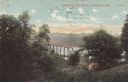
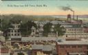
| Date: | 1905 |
|---|---|
| Description: | Elevated view toward the lumber company. A bridge over a river is in the foreground. Caption reads: "Looking South from City Hall Tower, Wausau, Wis." |

| Date: | |
|---|---|
| Description: | Elevated view looking down towards a steamboat pulling a raft of lumber on the Mississippi River. Caption reads: "Mississippi River at Prescott, Wis." |
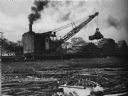
| Date: | 1936 |
|---|---|
| Description: | View from river of a machine/crane moving bundles of pulpwood to be made into paper. |
| Date: | 06 12 1908 |
|---|---|
| Description: | Colorized postcard looking down hill of the Fox River through the trees. A bridge is spanning the river, and piles of lumber are on the shoreline. Caption ... |

| Date: | 08 03 1905 |
|---|---|
| Description: | Photographic postcard of a scene of the Fox River near Lawrence University. The Main Building at Lawrence University can be seen in the background on the r... |

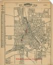
| Date: | 1972 |
|---|---|
| Description: | This map on 5 sheets features a title page sheet with business directory and shows section numbers, roads, railroads, saw mills, churches, blacksmith shops... |

| Date: | |
|---|---|
| Description: | Memohead of the Milwaukee Dry Dock Company, which operated two docks, with a view of a dock with ships, planks of wood, buildings, and the slogan, "Electri... |

| Date: | 1872 |
|---|---|
| Description: | This map, which includes eastern Iowa, northern Illinois and a portion of Michigan's Upper peninsula, shows the township survey grid and identifies countie... |

| Date: | 1870 |
|---|---|
| Description: | A map of Iowa County, Wisconsin mounted on cloth that shows the villages of Avoca, Mifflin, Linden, Arena, Helena Station, Highland, Dodgeville, as well as... |

| Date: | 1896 |
|---|---|
| Description: | A map of Iron County, Wisconsin, shows vacant Wisconsin Central Rail Road lands, settlers houses, land sold by Wisconsin Central R.R., schools, churches, s... |

| Date: | |
|---|---|
| Description: | Map of northern Iron County, Wisconsin, shows town sections and railroads in the towns of Saxon, Kimball, and Gurney. It also includes the area of the La P... |

| Date: | 1917 |
|---|---|
| Description: | Shows landownership, buildings, and swamps around Rest Lake in Vilas County, Wisconsin. Relief shown by contours. "May 1917." From the E.P. Sherry papers r... |

| Date: | 1926 |
|---|---|
| Description: | Relief shown by hachures. Shows local streets, roads, railroads, businesses, Half Moon Lake, Chippewa River, and log reservoir. |

| Date: | 1858 |
|---|---|
| Description: | Map shows township borders, marshes, pine timber, roads, railroads, and mills. The townships are are shown in blue/green, pink, and yellow. The map include... |
| Date: | |
|---|---|
| Description: | Elevated view of the saw mill. Lumber is stacked in front of several buildings and railroad tracks. Caption reads: "Saw Mill, Bayfield, Wis." |
| Date: | |
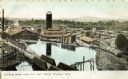
|---|---|
| Description: | Colorized postcard of an elevated view of Berlin Shops. There are piles of lumber and freight cars in the foreground. A factory with a water tower is in th... |
| Date: | 1927 |
|---|---|
| Description: | This map shows a plat of city, a numbering system, local streets, railroads, and part of the Rock River. The map is indexed by street name and reads: "Copy... |

| Date: | 1899 |
|---|---|
| Description: | This map is ink on tracing cloth and shows lot and block numbers and dimensions, streets, the high school park, and survey monuments. The map is oriented ... |

| Date: | 1974 |
|---|---|
| Description: | Map of Wisconsin with drawings illustrating historic places and events throughout the state. The Great Seal of the State of Wisconsin appears at the top ri... |
If you didn't find the material you searched for, our Library Reference Staff can help.
Call our reference desk at 608-264-6535 or email us at: