 Filter: Categories of Wisconsin Historical Images
Filter: FORMAT_TYPE of prints, photomechanical
Filter: Subject of cities and towns
Filter: Subject of science
Filter: Categories of Wisconsin Historical Images
Filter: FORMAT_TYPE of prints, photomechanical
Filter: Subject of cities and towns
Filter: Subject of science
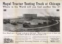
| Date: | 1915 |
|---|---|
| Description: | Advertising poster for Mogul tractors featuring an elevated view of a Mogul 8-16, 12-25 and 30-60 tractors on a test track in Chicago, Illinois. Includes t... |
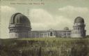
| Date: | 1905 |
|---|---|
| Description: | View across field towards the observatory. Caption reads: "Yerkes Observatory, Lake Geneva, Wis." |

| Date: | 1855 |
|---|---|
| Description: | Map reads "Our Country" which is accompanied by a sailor with a flag to the left and workers rejoicing under the Constitution and Laws to the right. Across... |
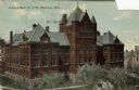
| Date: | 1910 |
|---|---|
| Description: | Elevated view looking northwest of Science Hall on the University of Wisconsin-Madison campus. Part of the Chemical Laboratory is in the background on the ... |
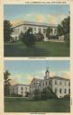
| Date: | 1925 |
|---|---|
| Description: | Postcard view of Science Hall on the University of Wisconsin-Madison campus. Elevated view looking towards the northwest. The Chemical Laboratory is on the... |

| Date: | 1910 |
|---|---|
| Description: | Cyanotype print of Science Hall across Park Street, looking northeast, on the University of Wisconsin-Madison campus. |

| Date: | 1910 |
|---|---|
| Description: | Cyanotype view across Bascom Hill of south facade entrance of Science Hall on the University of Wisconsin-Madison campus. |
| Date: | 1905 |
|---|---|
| Description: | Science Hall main entrance at the intersection of Park Street and Langdon Street on the University of Wisconsin-Madison campus. Caption reads: "Science Hal... |
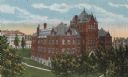
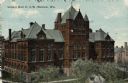
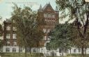
| Date: | |
|---|---|
| Description: | Alexander Gymnasium and Chemistry Institute on the campus of Lawrence University. Caption reads: "Lawrence College, Appleton, Wis." |

| Date: | 1866 |
|---|---|
| Description: | This thematic shows the effects that Lake Michigan has had on Wisconsin mean temperatures in January and July. The map shows counties, some cities, rivers ... |

| Date: | 1865 |
|---|---|
| Description: | Drawn the last year of the Civil War, this thematic map shows the effects that Lake Michigan has had on Wisconsin temperatures in January and July. The map... |

| Date: | 06 1887 |
|---|---|
| Description: | A map of southern Wisconsin, from the Illinois state border in the south to Rocky Run, Wisconsin in the north for the Coast and Geodetic Survey, showing th... |

| Date: | 1836 |
|---|---|
| Description: | This map depicts Wisconsin and Michigan territories in 1836. It includes the area from Michigan to the Missouri River and Lake Winnipeg, and it shows the e... |
| Date: | 1911 |
|---|---|
| Description: | Elevated view of Science Hall at the University of Wisconsin. Located on Park Street at the end of Langdon Street. Caption reads: "Science Hall, U. of W., ... |

| Date: | 09 09 1910 |
|---|---|
| Description: | The text on front reads: "Int. of Geo. J. Kelnhofer's General Store. Rib Lake, Wis." A man is standing in the central aisle, and a girl, holding a cat, is ... |
If you didn't find the material you searched for, our Library Reference Staff can help.
Call our reference desk at 608-264-6535 or email us at: