 Filter: Categories of Wisconsin Historical Images
Filter: FORMAT_TYPE of prints, photomechanical
Filter: Subject of city halls
Filter: Subject of roads
Filter: Categories of Wisconsin Historical Images
Filter: FORMAT_TYPE of prints, photomechanical
Filter: Subject of city halls
Filter: Subject of roads
| Date: | |
|---|---|
| Description: | Color image of City Hall with a welcome sign on the front of the building. The Henry Bergh monument fountain is in front, and a trolley is on the left si... |

| Date: | 1909 |
|---|---|
| Description: | Elevated view of City Hall. Above the image is the title. location, and "Die Stadthalle." On the bottom of the image is written "This is not so attractive... |

| Date: | 1895 |
|---|---|
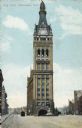
| Description: | The Milwaukee Sentinel Semi-Centennial Souvenir. City Hall and street in front with horse-drawn carriages and pedestrians. |
| Date: | 1904 |
|---|---|
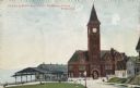
| Description: | The station with the clock tower is on the right, and the tracks and train shed are on the left. Pedestrians are on the lawn nearby, and houses are on the ... |

| Date: | 1926 |
|---|---|
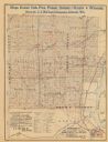
| Description: | A map of Lincoln County, Wisconsin that shows the township and range grid, towns, cities and villages, lakes and streams, residences, churches, school hous... |

| Date: | 1903 |
|---|---|
| Description: | This 1903 map of Outagamie County, Wisconsin, shows the township and range grid, towns, sections, cities and villages, landownership and acreages, rural ma... |

| Date: | |
|---|---|
| Description: | This 1907 map of Outagamie County, Wisconsin, shows the township and range grid, towns, sections, cities and villages, railroads, wagon roads, churches, sc... |

| Date: | 1922 |
|---|---|
| Description: | This map of Outagamie County, Wisconsin, from the first half of the 20th century, shows the township and range grid, towns, sections, cities and villages, ... |

| Date: | 1913 |
|---|---|
| Description: | This 1913 map of Pepin County, Wisconsin, shows the township and range grid, towns, villages, rural routes, railroads, roads, schools, churches, cemeteries... |

| Date: | 1922 |
|---|---|
| Description: | This map of Pierce County, Wisconsin, from the first half of the 20th century, shows the township and range grid, towns, sections, villages, roads, railroa... |

| Date: | |
|---|---|
| Description: | This map from the early 20th century shows the township and range grid, towns, sections, cities and villages, railroads, roads, schools, churches, cemeteri... |

| Date: | 1914 |
|---|---|
| Description: | This 1914 map of Price County, Wisconsin, shows land for sale by the Good Land Company and Dewitt van Ostrand of Phillips. Also shown are the township and ... |

| Date: | 1920 |
|---|---|
| Description: | This map shows the township and range system, sections, schools, churches, cemeteries, town halls, roads, railroads, and lakes and streams in Shawano Count... |

| Date: | 1917 |
|---|---|
| Description: | This 1917 map of Ashland County, Wisconsin, shows the township and range system, towns, sections, cities and villages, the Bad River Indian Reservation, ra... |

| Date: | 1918 |
|---|---|
| Description: | This 1918 map of Chippewa County, Wisconsin, shows the township and range grid, towns, sections, cities and villages, rural residences, churches, schools, ... |

| Date: | 1914 |
|---|---|
| Description: | Map shows school houses, creameries, post offices, saw mills, grist mills, churches, cemeteries, town halls, stores, roads, state roads, and railroads. "Co... |
| Date: | 1890 |
|---|---|
| Description: | The map shows roads and railroads, houses, schools, town halls, and other points of interest in parts of Shawano, Oconto, and Brown counties. The lower lef... |

| Date: | 1952 |
|---|---|
| Description: | View across street towards the Ephraim Village Hall. Automobiles are parked on both sides of the street. Text on reverse reads: "A view of Ephraim's pic... |
If you didn't find the material you searched for, our Library Reference Staff can help.
Call our reference desk at 608-264-6535 or email us at:
