 Filter: Categories of Wisconsin Historical Images
Filter: FORMAT_TYPE of prints, photomechanical
Filter: Subject of city halls
Filter: Subject of street-railroads
Filter: Categories of Wisconsin Historical Images
Filter: FORMAT_TYPE of prints, photomechanical
Filter: Subject of city halls
Filter: Subject of street-railroads

| Date: | 1903 |
|---|---|
| Description: | This 1903 map of Outagamie County, Wisconsin, shows the township and range grid, towns, sections, cities and villages, landownership and acreages, rural ma... |
| Date: | |
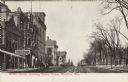
|---|---|
| Description: | View down Mifflin Street, facing east along the Capitol Square. The Opera House and City Hall are on the left. There is a large sign over the sidewalk for ... |
If you didn't find the material you searched for, our Library Reference Staff can help.
Call our reference desk at 608-264-6535 or email us at: