 Filter: Categories of Wisconsin Historical Images
Filter: FORMAT_TYPE of prints, photomechanical
Filter: Subject of dairy products industry
Filter: Subject of land use
Filter: Categories of Wisconsin Historical Images
Filter: FORMAT_TYPE of prints, photomechanical
Filter: Subject of dairy products industry
Filter: Subject of land use
| Date: | 1910 |
|---|---|
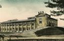
| Description: | View of the Van Camp Condensed Milk Factory. A driveway on the right leads up a small hill to the right side of the factory. Caption reads: "Van Camp Conde... |

| Date: | 1910 |
|---|---|
| Description: | "There never was but one Crop of Land. There never will be another." Shows towns, boundaries, roads, schoolhouses, sawmills, cheese factories, and creameri... |
| Date: | 1880 |
|---|---|
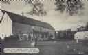
| Description: | An illustration depicting the cheese factory and dry goods store of J.G. Pickett at Pickett's Station. |
| Date: | |
|---|---|
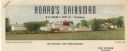
| Description: | Letterhead of Hoard's Dairyman, the "national dairy farm magazine" published by former governor and proponent of the Wisconsin dairy industry, William Demp... |
| Date: | 10 18 1939 |
|---|---|
| Description: | Postcard submitted to the state of Wisconsin for trademark registration. On the front of the postcard is the slogan: You can 'whip' our cream but you can't... |

| Date: | |
|---|---|
| Description: | Letterhead of Hoard's Dairyman, "The National Dairy Farm Magazine," with a bird's eye view of the company farm buildings, and a mailbox with an upraised fl... |

| Date: | |
|---|---|
| Description: | This 1907 map of Outagamie County, Wisconsin, shows the township and range grid, towns, sections, cities and villages, railroads, wagon roads, churches, sc... |

| Date: | 1922 |
|---|---|
| Description: | This map of Outagamie County, Wisconsin, from the first half of the 20th century, shows the township and range grid, towns, sections, cities and villages, ... |

| Date: | 1925 |
|---|---|
| Description: | This map of Price County, Wisconsin, from the early 20th century shows the township and range system, towns, sections, cities and villages, railroads, high... |

| Date: | 1896 |
|---|---|
| Description: | This late 19th century map of Walworth County, Wisconsin, shows the township and range grid, towns, sections, villages and post offices, roads, railroads, ... |

| Date: | 1914 |
|---|---|
| Description: | Map shows school houses, creameries, post offices, saw mills, grist mills, churches, cemeteries, town halls, stores, roads, state roads, and railroads. "Co... |
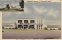
| Date: | 1951 |
|---|---|
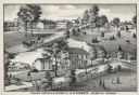
| Description: | Illustrated postcard view of the exterior of Bancroft Dairy, and an inset at top left of Charmany Farms. Near the entrance of the dairy are chairs set arou... |
If you didn't find the material you searched for, our Library Reference Staff can help.
Call our reference desk at 608-264-6535 or email us at: