 Filter: Categories of Wisconsin Historical Images
Filter: FORMAT_TYPE of prints, photomechanical
Filter: Subject of deserts
Filter: Subject of water
Filter: Categories of Wisconsin Historical Images
Filter: FORMAT_TYPE of prints, photomechanical
Filter: Subject of deserts
Filter: Subject of water
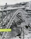
| Date: | 1959 |
|---|---|
| Description: | An International truck sits on a bridge spanning Glen Canyon and the Colorado River. |

| Date: | 1929 |
|---|---|
| Description: | An International truck pours 30-foot sections of a lock. |
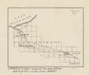
| Date: | |
|---|---|
| Description: | This map shows the Michigan-Wisconsin boundary in Iron, Vilas, and Forest counties, Wisconsin, and Gogebic and Iron counties, Michigan. The Montreal River... |

| Date: | 1920 |
|---|---|
| Description: | This blueprint map covers the boundary area between Lake Superior and the Lac Vieux Desert. The map reads: "Land lines, streams, lakes, railroads, cities a... |
If you didn't find the material you searched for, our Library Reference Staff can help.
Call our reference desk at 608-264-6535 or email us at: