 Filter: Categories of Wisconsin Historical Images
Filter: FORMAT_TYPE of prints, photomechanical
Filter: Subject of deserts
Filter: Categories of Wisconsin Historical Images
Filter: FORMAT_TYPE of prints, photomechanical
Filter: Subject of deserts
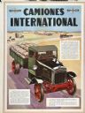
| Date: | 1929 |
|---|---|
| Description: | South American advertising poster for International trucks showing a color illustration of a truck hauling sacks in a desert-like environment with a horse-... |

| Date: | 1978 |
|---|---|
| Description: | Front cover of an advertising brochure for the 1978 International Scout SS II pickup. Features color photograph of a man driving down a sand dune. |

| Date: | 1932 |
|---|---|
| Description: | An International Model A-8 truck drives through the desert while laying the Iraq pipe line. |
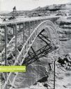
| Date: | 1959 |
|---|---|
| Description: | An International truck sits on a bridge spanning Glen Canyon and the Colorado River. |

| Date: | 1959 |
|---|---|
| Description: | International trucks parked near a bridge construction site. |

| Date: | 1929 |
|---|---|
| Description: | An International truck pours 30-foot sections of a lock. |
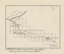
| Date: | |
|---|---|
| Description: | This map shows the Michigan-Wisconsin boundary in Iron, Vilas, and Forest counties, Wisconsin, and Gogebic and Iron counties, Michigan. The Montreal River... |
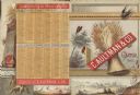
| Date: | 1883 |
|---|---|
| Description: | C. Aultman & Co. catalog cover and back cover. On the front is a shock of wheat, a bird and a butterfly, and on the bottom a farm landscape. On the back co... |

| Date: | |
|---|---|
| Description: | Combination of photograph and colored drawing. "International Scout pictured traversing a Middle Eastern desert." (According to the collection description.... |

| Date: | 1920 |
|---|---|
| Description: | This blueprint map covers the boundary area between Lake Superior and the Lac Vieux Desert. The map reads: "Land lines, streams, lakes, railroads, cities a... |
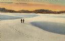
| Date: | |
|---|---|
| Description: | Tinted lithograph of two people walking in a white sand desert. Mountains are in the distance. Caption on the reverse of postcard reads: "Really not sand a... |
If you didn't find the material you searched for, our Library Reference Staff can help.
Call our reference desk at 608-264-6535 or email us at: