 Filter: Categories of Wisconsin Historical Images
Filter: FORMAT_TYPE of prints, photomechanical
Filter: Subject of drawing
Filter: Subject of land
Filter: Categories of Wisconsin Historical Images
Filter: FORMAT_TYPE of prints, photomechanical
Filter: Subject of drawing
Filter: Subject of land
| Date: | |
|---|---|
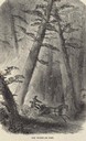
| Description: | Illustration of a man driving a horse-drawn wagon out of burning woodland. |

| Date: | 1955 |
|---|---|
| Description: | Artist's conception of ancient village of Aztalan, fortified with high walls surrounding it. |

| Date: | 1900 |
|---|---|
| Description: | A group of immigrants, both children and adults, who have just arrived at Ellis Island. |
| Date: | 07 22 1905 |
|---|---|
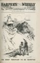
| Description: | A cartoon titled "The First Mountain To Be Removed" showing Uncle Sam and Theodore Roosevelt looking at a mountain shaped like a skeleton wearing a mask an... |

| Date: | 1851 |
|---|---|
| Description: | Map of a portion of Merton including the Bark River, a mill, Fort Hill, and Indian mounds. |

| Date: | 1937 |
|---|---|
| Description: | A pictorial, hydrographic map shows sailing courses, historical and contemporary coastal attractions, roads, and the contour depths of Green Lake, Wisconsi... |
| Date: | 07 1976 |
|---|---|
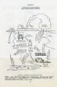
| Description: | Diagram showing environmental means by which humans can be exposed to radiation from nuclear power plants. |

| Date: | 1930 |
|---|---|
| Description: | These 40 hand-drawn maps depict the survey townships in Oneida County, Wisconsin, on printed township grids. Lakes, rivers, and waterfront properties are d... |
| Date: | |
|---|---|
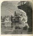
| Description: | Engraved view of "The Jaws" in the Wisconsin Dells. |
| Date: | 03 06 1869 |
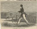
|---|---|
| Description: | Engraved image of a man in a top hat and tails riding a velocipede. Another rider is in the background. |

| Date: | 1910 |
|---|---|
| Description: | This map is ink on paper. Shows Bruce’s proposed railway route and Moon’s railroad survey route along the Flambeau River, in parts of Lake and Eisenstein t... |

| Date: | 1800 |
|---|---|
| Description: | The map is ink and pencil on paper. Map shows the location of the Ashland Lumber Company as well as a portion of Ashland County. Portions of the map are in... |

| Date: | 1970 |
|---|---|
| Description: | Editorial cartoon depicting Rodin's "The Thinker" wearing a gas mask. The figure is surrounded by pollution, with a factory spewing smoke in the background... |

| Date: | 1828 |
|---|---|
| Description: | Map of the Louisville and Portland Canal on the Ohio River. The map shows Louisville, Shippingsport, Clarksville, Jeffersonville, Gravel Island, Corn Islan... |

| Date: | 03 28 1892 |
|---|---|
| Description: | Newspaper clipping cartoon drawing of Jeremiah Rusk as a towering figure standing above a small crowd of men in a field. Rusk wears a hat and vest, his sle... |

| Date: | |
|---|---|
| Description: | Poster promoting land rights for Native Americans. Produced by the Association on American Indian Affairs, Inc., 432 Park Avenue South, New York. Poster te... |

| Date: | |
|---|---|
| Description: | Drawing of a map showing the cruise routes from Eagle Inn Dock and the points of interest. There is a schedule and rates on the reverse. |

| Date: | 1612 |
|---|---|
| Description: | Map of New France, the area that is now eastern Canada and north eastern United States, showing lakes, rivers, and landforms. The locations of several Nati... |
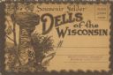
| Date: | 1930 |
|---|---|
| Description: | Text reads: "Souvenir Folder. Dells of the Wisconsin." The mailing side/front of a souvenir view folder containing eleven accordion folded, double-sided co... |
| Date: | 1930 |
|---|---|
| Description: | Text on mailing side reads: "Souvenir Folder. Dells of the Wisconsin." The back of a souvenir view folder containing eleven accordion folded, double-sided ... |
If you didn't find the material you searched for, our Library Reference Staff can help.
Call our reference desk at 608-264-6535 or email us at: