Filter: Categories of Wisconsin Historical Images
Filter: FORMAT_TYPE of prints, photomechanical
Filter: Subject of drawing
Filter: Subject of streets
Filter: Categories of Wisconsin Historical Images
Filter: FORMAT_TYPE of prints, photomechanical
Filter: Subject of drawing
Filter: Subject of streets

| Date: | 01 09 1883 |
|---|---|
| Description: | A large crowd is on the street surrounding the burning building. Fire fighters are struggling with horses pulling the fire engine, and on the left a group... |

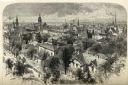
| Date: | 1978 |
|---|---|
| Description: | Bird’s-eye view map. Shows Madison from the edge of Lake Monona stretching west. Above the map are clouds and in the distance is the edge of the world and ... |

| Date: | 1828 |
|---|---|
| Description: | Map of the Louisville and Portland Canal on the Ohio River. The map shows Louisville, Shippingsport, Clarksville, Jeffersonville, Gravel Island, Corn Islan... |

| Date: | 1836 |
|---|---|
| Description: | This map shows lot and block numbers, streets, a proposed canal basin, Fort Winnebago, and the Wisconsin and Fox Rivers. Relief is shown by hachures and no... |
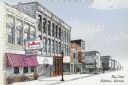
| Date: | 1995 |
|---|---|
| Description: | Text on front reads: "Main Street, Watertown, Wisconsin." On the reverse: "Front: A present day view of Main Street in downtown Watertown, Wisconsin, sketc... |
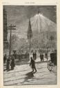
| Date: | 01 14 1882 |
|---|---|
| Description: | A drawing showing Madison Square at night, lit by electric lighting at the top of a mast. Men and women are strolling on the sidewalks and walking on the s... |
If you didn't find the material you searched for, our Library Reference Staff can help.
Call our reference desk at 608-264-6535 or email us at: