 Filter: Categories of Wisconsin Historical Images
Filter: FORMAT_TYPE of prints, photomechanical
Filter: Subject of education
Filter: Subject of indians of north america
Filter: Categories of Wisconsin Historical Images
Filter: FORMAT_TYPE of prints, photomechanical
Filter: Subject of education
Filter: Subject of indians of north america
| Date: | |
|---|---|
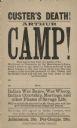
| Description: | Poster of a performance by Arthur Camp, who was kidnapped by the Menominees from the banks of the Wolf River, in Wisconsin, at the age of 4. He was present... |
| Date: | 1912 |
|---|---|
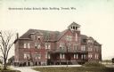
| Description: | Exterior view of the main building. Caption reads: "Government Indian School, Main Building, Tomah, Wis." |
| Date: | 1910 |
|---|---|
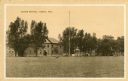
| Description: | View across lawn toward the Indian School. Caption reads: "Indian School, Wis." |
| Date: | 1940 |
|---|---|
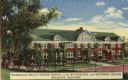
| Description: | Winnebago Indian Mission School of the Evangelical and Reformed Church. This boarding school for Indian children was established in 1917 near Black River F... |

| Date: | 1889 |
|---|---|
| Description: | Three-quarter length studio portrait in front of a painted backdrop of five Hayward Indian School students, possibly a basketball team, from L to R: John C... |

| Date: | 1900 |
|---|---|
| Description: | Perspective drawing of the buildings at the Hayward Indian School. There is a man in a boat in the right foreground and an empty boat in the left foregroun... |

| Date: | 1943 |
|---|---|
| Description: | A map that shows the lands for sale by the Tomahawk Land Company of Tomahawk, Wisconsin, in the counties of Langlade, Lincoln, Oneida, and Price. The map s... |

| Date: | 1939 |
|---|---|
| Description: | This map shows the towns to Gingles, Sanborn, and Guney as well as Chequamegon Bay, Kakagon River, White River, Marengo River, Bad River, Potato River, Vau... |

| Date: | 1880 |
|---|---|
| Description: | A hand-colored map of the Chippewa, Price, Taylor and the northern part of Clark counties, which shows the locations of farmhouses, schoolhouses, churches,... |

| Date: | 1896 |
|---|---|
| Description: | A map of Iron County, Wisconsin, shows vacant Wisconsin Central Rail Road lands, settlers houses, land sold by Wisconsin Central R.R., schools, churches, s... |

| Date: | 1898 |
|---|---|
| Description: | A map of Iron County, Wisconsin, shows vacant Wisconsin Central Rail Road lands, settlers houses, land sold by Wisconsin Central R.R., schools, churches, s... |

| Date: | |
|---|---|
| Description: | A map that shows the Wisconsin Central Railway land grant lands for sale by the Soo Line, the Chicago, Milwaukee, and St. Paul Railway. Town sections, lak... |

| Date: | 1920 |
|---|---|
| Description: | This map of Sawyer County, Wisconsin, from the early 20th century shows the township and range system, towns, sections, cities and villages, railroads, hig... |

| Date: | 1897 |
|---|---|
| Description: | This 1897 map of Sawyer County, Wisconsin, shows the township and range system, sections, roads, farm houses, camps, school houses, dams, bridges, Indian r... |

| Date: | 1900 |
|---|---|
| Description: | This map of Sawyer County, Wisconsin, shows the numbered "sub-school-districts of the town of Hayward" school houses, and the Indian reservation. The towns... |

| Date: | 1902 |
|---|---|
| Description: | This 1902 map of the eastern portion of Sawyer County, Wisconsin, shows the township and range system, sections, roads, farm houses, camps, school houses, ... |

| Date: | 1920 |
|---|---|
| Description: | This map shows the township and range system, sections, schools, churches, cemeteries, town halls, roads, railroads, and lakes and streams in Shawano Count... |

| Date: | 1933 |
|---|---|
| Description: | This map shows the township and range system, sections, cities and villages, schools, roads, railroads, and lakes and streams in Shawano County, which at t... |

| Date: | 1887 |
|---|---|
| Description: | This 1887 map of Ashland County, Wisconsin, shows the township and range system, sections, railroads, vacant Wisconsin Central Railroad land, state and "go... |

| Date: | 1900 |
|---|---|
| Description: | This 1900 map shows the township and range system, sections, cities and villages, railroads, roads, vacant land and land sold by the Wisconsin Central Rail... |
If you didn't find the material you searched for, our Library Reference Staff can help.
Call our reference desk at 608-264-6535 or email us at: