 Filter: Categories of Wisconsin Historical Images
Filter: FORMAT_TYPE of prints, photomechanical
Filter: Subject of engraving
Filter: Subject of mountains
Filter: Categories of Wisconsin Historical Images
Filter: FORMAT_TYPE of prints, photomechanical
Filter: Subject of engraving
Filter: Subject of mountains
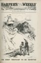
| Date: | 07 22 1905 |
|---|---|
| Description: | A cartoon titled "The First Mountain To Be Removed" showing Uncle Sam and Theodore Roosevelt looking at a mountain shaped like a skeleton wearing a mask an... |
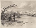
| Date: | 1884 |
|---|---|
| Description: | Small group of Native Americans spearing fish through ice on a river. Mountains can be seen in the background. |

| Date: | 08 1892 |
|---|---|
| Description: | Engraving, probably after a photograph, showing Frank Lenz posing with his safety bicycle near the stone arch entrance of a canal tunnel cut through a moun... |

| Date: | 1780 |
|---|---|
| Description: | Detailed topographical and political map of the area from Lake Champlain to Albany and the Hudson River. Relief is shown through hachures. The map shows ci... |

| Date: | 1720 |
|---|---|
| Description: | Map showing the course of the Mississippi River from the Gulf of Mexico up past Lake Superior into Canada. It shows the towns, Native American tribes and l... |

| Date: | 1795 |
|---|---|
| Description: | Map of the new state of Tennessee. It shows borders, numerous boundary lines (particularly Native American boundaries), towns (European and Native American... |

| Date: | 1796 |
|---|---|
| Description: | Map of the new state of Tennessee. It shows borders, numerous boundary lines (particularly Native American boundaries), towns (European and Native American... |

| Date: | 1800 |
|---|---|
| Description: | Map of the new state of Tennessee. It shows borders, numerous boundary lines (particularly Native American boundaries), towns (European and Native American... |

| Date: | 1795 |
|---|---|
| Description: | Detailed map of Kentucky and most of Tennessee. The map shows the borders, counties, cities, towns, Native American towns, forts, roads, mountains, lakes, ... |

| Date: | 1795 |
|---|---|
| Description: | Detailed map of Kentucky showing counties, cities, towns, Native American towns, forts, salt licks, roads, prairies, mountains, lakes, and rivers. Numerous... |

| Date: | 1766 |
|---|---|
| Description: | Map of the region south of Lake Erie to the Ohio River. It shows forts, towns, Native American towns, mines, roads, mountains, swamps, lakes, and rivers. T... |

| Date: | 1755 |
|---|---|
| Description: | Map of the Great Lakes region during the French and Indian War. It shows in great detail the territories, borders and boundary lines, Native American tribe... |
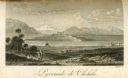
| Date: | 1816 |
|---|---|
| Description: | The four-stepped, low-rising Pyramid of Cholula, covered in sparse vegetation, stands in a flat valley, surrounded by distant mountains. A stairway leads u... |
If you didn't find the material you searched for, our Library Reference Staff can help.
Call our reference desk at 608-264-6535 or email us at: