 Filter: Categories of Wisconsin Historical Images
Filter: FORMAT_TYPE of prints, photomechanical
Filter: Subject of factories
Filter: Subject of service industries
Filter: Categories of Wisconsin Historical Images
Filter: FORMAT_TYPE of prints, photomechanical
Filter: Subject of factories
Filter: Subject of service industries

| Date: | 1896 |
|---|---|
| Description: | Bird's-eye view of Washburn, with twenty vignettes around side, water in foreground with docks and lumber corral. Thirty-three locations identified in key ... |

| Date: | 1874 |
|---|---|
| Description: | Bird's-eye view of Waukesha, looking southwest, with insets of State Industrial School, Court House, and Fountain Spring House. |

| Date: | 1910 |
|---|---|
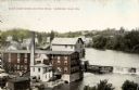
| Description: | Chippewa Falls from the south side of the river below the falls. Includes the Sheely House Tavern, railway buildings, box cars, a train with five passenger... |
| Date: | 1910 |
|---|---|
| Description: | Elevated view of the White Wagon Works and Rock Mills. Caption reads: "White Wagon Works and Rock Mills, Sheboygan Falls, Wis." |

| Date: | 1936 |
|---|---|
| Description: | Cover of an advertising brochure for the International C-300 cab-over-engine truck. Features a color illustration of men working around an Empire Cartage C... |
| Date: | |
|---|---|
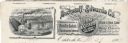
| Description: | Memohead of the Buckstaff-Edwards Company of Oshkosh, Wisconsin, manufacturers of coffins and caskets and wholesale dealers in caskets and undertaking supp... |

| Date: | 1905 |
|---|---|
| Description: | Elevated view of the Pabst Brewery shipping yard showing several teams of horses hitched to wagons loaded with barrels of beer. A man holds the reins of ea... |

| Date: | 1886 |
|---|---|
| Description: | This map has relief shown by hachures and includes a list of plats in order of date of record, laws which vacate plats, plats not shown as upon the county ... |

| Date: | 1888 |
|---|---|
| Description: | This map has relief shown by hachures and features inset maps of a plat of E.D. Clinton and Blackwell’s add’n to the City of La Crosse. Wards (1-10) shaded... |

| Date: | |
|---|---|
| Description: | Stamp advertising the city of Sheboygan, specifically its many industries. In addition to the stamp title, the stamp includes an illustration of factories,... |

| Date: | 1858 |
|---|---|
| Description: | This map is hand-colored and mounted on cloth and shows lot and block numbers and dimensions, landownership, streets, railroads, selected buildings, fair g... |

| Date: | 06 1890 |
|---|---|
| Description: | This map shows building use, railroads, tramways, lumber yards, roads, watchman’s stations, and steam pipes. Also included is text about buildings, Clapp a... |

| Date: | 1970 |
|---|---|
| Description: | This map shows colored-coded land use with a legend in the bottom margin. Land classifications include: Year-round Residential (yellow), Seasonal Residenti... |

| Date: | 1892 |
|---|---|
| Description: | A Sanborn map of St. Louis, which is six miles southwest of South Superior. |

| Date: | |
|---|---|
| Description: | Colorized postcard view of the Chevrolet Motor Company headquarters and auto plant. Caption reads: "Chevrolet Motor Company, Janesville, Wis." |
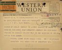
| Date: | 07 12 1934 |
|---|---|
| Description: | Telegram received July 13 reads: "WM Green, President of American Federation of Labor = A F OF L BLDG WASHDC = Answer of Kohler Company to latest demands o... |

| Date: | 1915 |
|---|---|
| Description: | A Sanborn fire insurance map of Sauk City created in 1915. |

| Date: | 1915 |
|---|---|
| Description: | A Sanborn fire insurance map of Sauk City created in 1915. |
If you didn't find the material you searched for, our Library Reference Staff can help.
Call our reference desk at 608-264-6535 or email us at:

