 Filter: Categories of Wisconsin Historical Images
Filter: FORMAT_TYPE of prints, photomechanical
Filter: Subject of fire extinction
Filter: Subject of streets
Filter: Categories of Wisconsin Historical Images
Filter: FORMAT_TYPE of prints, photomechanical
Filter: Subject of fire extinction
Filter: Subject of streets

| Date: | 1896 |
|---|---|
| Description: | A portion of John B. Heim's map of the Water Works System of Madison showing the size of the third Wisconsin Capitol (228' x 226') in comparison with the C... |

| Date: | 01 09 1883 |
|---|---|
| Description: | A large crowd is on the street surrounding the burning building. Fire fighters are struggling with horses pulling the fire engine, and on the left a group... |
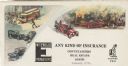
| Date: | |
|---|---|
| Description: | Letterhead of the Wm. Ewig Company, an insurance company in Milwaukee, Wisconsin, with full-color depictions of a scene with three traffic accidents involv... |

| Date: | 1947 |
|---|---|
| Description: | Lower left hand corner features a legend. "Drawn 1938, revised 1947." Shows water mains, hydrants, corporation limits, city ward divisions, fire proof buil... |

| Date: | 1900 |
|---|---|
| Description: | This map of Three Lakes shows forest fire lookout towers, picnic grounds, an airport, roads, and railroad. The map features text boxes on the Village of Th... |

| Date: | 06 1890 |
|---|---|
| Description: | This map shows building use, railroads, tramways, lumber yards, roads, watchman’s stations, and steam pipes. Also included is text about buildings, Clapp a... |

| Date: | 12 1912 |
|---|---|
| Description: | Sanborn map of Sun Prairie, which includes an index and information about water facilities and the fire department. Includes a small inset map of the State... |
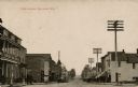
| Date: | 1910 |
|---|---|
| Description: | View down a commercial street lined with businesses. A barber pole is on the left, and a fire hydrant is on the right street corner. Large power poles are ... |

| Date: | 04 1901 |
|---|---|
| Description: | A Sanborn map of Watertown, including an index and a key. |

| Date: | |
|---|---|
| Description: | View of the Marshfield City Hall. The fire department is on the right, and the library is behind it. Caption reads: "City Hall and Library, Marshfield, Wis... |

| Date: | 1908 |
|---|---|
| Description: | A Sanborn fire map of Brodhead. Includes an inset at top right showing distances from P.O. |
If you didn't find the material you searched for, our Library Reference Staff can help.
Call our reference desk at 608-264-6535 or email us at: