 Filter: Categories of Wisconsin Historical Images
Filter: FORMAT_TYPE of prints, photomechanical
Filter: Subject of fishing
Filter: Subject of indians of north america
Filter: Categories of Wisconsin Historical Images
Filter: FORMAT_TYPE of prints, photomechanical
Filter: Subject of fishing
Filter: Subject of indians of north america

| Date: | 1930 |
|---|---|
| Description: | Pictorial map of Glacier National Park, Montana and Waterton Lakes National Park, Alberta. Illustrated by Joe Scheurle, it depicts white people, American ... |

| Date: | 1957 |
|---|---|
| Description: | Large Letter style postcard for Green Bay depicting various scenes in the letters that spell the name of the city. Caption reads: "Greetings from Green Bay... |

| Date: | 1939 |
|---|---|
| Description: | This map shows the towns to Gingles, Sanborn, and Guney as well as Chequamegon Bay, Kakagon River, White River, Marengo River, Bad River, Potato River, Vau... |
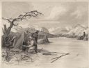
| Date: | 1884 |
|---|---|
| Description: | Small group of Native Americans spearing fish through ice on a river. Mountains can be seen in the background. |

| Date: | 1895 |
|---|---|
| Description: | This late 19th century map of northern Wisconsin and a portion of Michigan's Upper Peninsula shows the township and range grid, the (Lac du) Flambeau India... |

| Date: | 1972 |
|---|---|
| Description: | This colored map displays Wisconsin and bordering areas of Iowa, Minnesota, and Michigan. There is color-coding on the map to indicate National Forests, an... |

| Date: | 1971 |
|---|---|
| Description: | This colored map displays Wisconsin and bordering areas of Iowa, Minnesota, and Michigan. There is color-coding on the map to indicate National Forests, an... |

| Date: | 1973 |
|---|---|
| Description: | This colored map displays Wisconsin and bordering areas of Iowa, Minnesota, and Michigan. There is color-coding on the map to indicate National Forests, a... |

| Date: | 1962 |
|---|---|
| Description: | This colored map represents "Tour #2" of a series of driving tours of the state published by the Sperry & Hutchinson Company, in order to "help you enjoy W... |

| Date: | 1962 |
|---|---|
| Description: | This colored map represents "Tour #1" of a series of driving tours of the state published by the Sperry & Hutchinson Company, in order to "help you enjoy W... |

| Date: | |
|---|---|
| Description: | The non-mailing side of a wrap-around postcard cover. Glued inside is a folded series of two sided scenes of attractions in Central Wisconsin. Across the i... |
If you didn't find the material you searched for, our Library Reference Staff can help.
Call our reference desk at 608-264-6535 or email us at: