 Filter: Categories of Wisconsin Historical Images
Filter: FORMAT_TYPE of prints, photomechanical
Filter: Subject of fishing
Filter: Subject of land
Filter: Categories of Wisconsin Historical Images
Filter: FORMAT_TYPE of prints, photomechanical
Filter: Subject of fishing
Filter: Subject of land
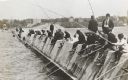
| Date: | 1910 |
|---|---|
| Description: | Long row of men in suits and hats fishing on the breakwater. |
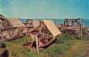
| Date: | 1967 |
|---|---|
| Description: | Fishing nets drying along the shore of Lake Michigan. |
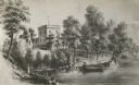
| Date: | 1863 |
|---|---|
| Description: | View of the shoreline on the Walker Castle grounds. Two men are boating while a young boy fishes from the shore. |

| Date: | 1930 |
|---|---|
| Description: | Pictorial map of Glacier National Park, Montana and Waterton Lakes National Park, Alberta. Illustrated by Joe Scheurle, it depicts white people, American ... |

| Date: | 1930 |
|---|---|
| Description: | The back of the pictorial map titled Recreational Map of Glacier National Park, Montana: Waterton Lakes National Park, Alberta. 14 panels of text and photo... |

| Date: | |
|---|---|
| Description: | Black and white postcard of the boat landing in front of Cliff House, a resort hotel, in Devil's Lake State Park. Two men show off their catch of seven fis... |

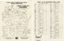
| Date: | 1916 |
|---|---|
| Description: | This map shows the locations of hunting and fishing resorts in the northern Wisconsin counties of Forest, Iron, Oneida, and Vilas, and in Gogebic County in... |

| Date: | 1903 |
|---|---|
| Description: | A map of northern Wisconsin and Michigan showing the names and locations hunting and fishing resorts in the area, as well as location of Chicago and North ... |

| Date: | 1914 |
|---|---|
| Description: | Two maps of northern Wisconsin counties of Ashland, Barron, Bayfield, Chippewa, Douglas, Forest, Iron, Langlade, Lincoln, Oneida, Polk, Price, Sawyer, Tayl... |
| Date: | 1956 |
|---|---|
| Description: | A map that identifies the trout lakes in Wisconsin and their proximity to cities. Text on the page of the map highlights the conservation actions taken by ... |

| Date: | 1939 |
|---|---|
| Description: | This map shows the towns to Gingles, Sanborn, and Guney as well as Chequamegon Bay, Kakagon River, White River, Marengo River, Bad River, Potato River, Vau... |

| Date: | 1936 |
|---|---|
| Description: | This pictorial tourist map from the Wisconsin Conservation Commission depicts vacation activities and identifies tourist destinations throughout the state.... |
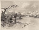
| Date: | 1884 |
|---|---|
| Description: | Small group of Native Americans spearing fish through ice on a river. Mountains can be seen in the background. |

| Date: | 1935 |
|---|---|
| Description: | This pictorial map of northern Bayfield County, Wisconsin, shows the Chequamegon National Forest, the Red Cliff Indian Reservation, highways and roads, and... |

| Date: | 1940 |
|---|---|
| Description: | Map shows hydrography and location of game fish in part of Vilas County, Wisconsin and Gogebic County, Michigan. |
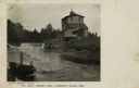
| Date: | 1905 |
|---|---|
| Description: | View of Tilden Mill and dam on Duncan Creek. In the foreground two men are standing and sitting on a large, flat boulder. Caption reads: "Tilden Mill, Chip... |

| Date: | 1966 |
|---|---|
| Description: | A colored map depiction of Door County, Wisconsin, with pictorial highlights, titled: "Door County — Wisconsin's Air Conditioned Peninsula Playground." |

| Date: | 1935 |
|---|---|
| Description: | This map shows rivers, lakes, communities, woods, fishing locations, and vacation destinations. The back of the map includes text about agricultural, sceni... |

| Date: | 1936 |
|---|---|
| Description: | This map shows campsites, trails, auto roads, surrounding townships, and points of interest, by including pictorial illustrations. Includes an inserted map... |
If you didn't find the material you searched for, our Library Reference Staff can help.
Call our reference desk at 608-264-6535 or email us at:
