 Filter: Categories of Wisconsin Historical Images
Filter: FORMAT_TYPE of prints, photomechanical
Filter: Subject of fortification
Filter: Creator Name of Unknown
Filter: Categories of Wisconsin Historical Images
Filter: FORMAT_TYPE of prints, photomechanical
Filter: Subject of fortification
Filter: Creator Name of Unknown

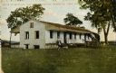
| Date: | 1830 |
|---|---|
| Description: | Illustration of Fort Crawford. Caption reads: "Fort Crawford in 1830, Prairie Du Chien, Wis." |
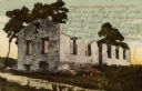
| Date: | 1910 |
|---|---|
| Description: | Fort Crawford. Caption reads: "Ruins of hospital, old Fort Crawford, Prairie du Chien, Wis." |
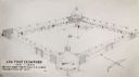
| Date: | 1817 |
|---|---|
| Description: | Sketch of an elevated view of Fort Crawford (1816-1829). |
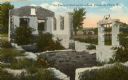
| Date: | 1900 |
|---|---|
| Description: | A view of the ruins of the guardhouse used in 1883. Caption reads: "Ruins of Fort Crawford, Prairie du Chien, Wis." |

| Date: | 1910 |
|---|---|
| Description: | Fort Crawford ruins. Caption reads: "Ruins of Old Fort Crawford, Prairie-du-Chien, Wis." |

| Date: | 1915 |
|---|---|
| Description: | Ruins of Fort Crawford. A windmill is in the background on the right. Caption reads: "Ruins of Fort Crawford, Prairie du Chien, Wis." |
| Date: | 1925 |
|---|---|
| Description: | Fort Crawford (the second site, showing ruins of the building of 1892-?). These are the ruins of the hospital. Caption reads: "The Ruins of Old Fort Crawfo... |

| Date: | 1855 |
|---|---|
| Description: | Fox-Wisconsin portage and canal map, when the canal was not yet built. From a map in the office of the city clerk at Portage. "The old trail, the location ... |
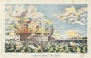
| Date: | 1861 |
|---|---|
| Description: | Color lithograph of the fort in the midst of the bombardment, published by Bingham & Dodd, Hartford, Connecticut. |
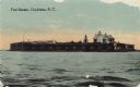
| Date: | 1915 |
|---|---|
| Description: | View across water toward Fort Sumter. Caption reads: "Fort Sumter, Charleston, S. C." |
| Date: | |
|---|---|
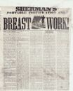
| Description: | An article discussing a new device to protect Union infantry from the enemy while they are advancing. |
| Date: | 1860 |
|---|---|
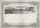
| Description: | Scene of 16 figures. A slave owner is raising his whip as black families are racing towards Fort Monroe, with some remaining behind picking cotton. The sla... |
| Date: | 1930 |
|---|---|
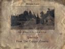
| Description: | Holiday card printed on a sheet of copper. It has a scene of log buildings, a stockade fence, and woods in the background. Above is the text "Michigan Copp... |

| Date: | |
|---|---|
| Description: | Valentine's Day card featuring a girl wearing a red uniform and a sword, standing on the roof of a fort. A boy in a tan uniform with a sword, is looking at... |

| Date: | 1914 |
|---|---|
| Description: | This map is a photostat copy from the original 1829 map in the War Department. The map shows location of Fort Howard, lots, land claims of Jacques Porlier ... |

| Date: | 1900 |
|---|---|
| Description: | This map of West Navarino shows plat of the town, lots by number, local streets, public square, The Fox River, and Fort Howard. The bottom of the map reads... |

| Date: | 1930 |
|---|---|
| Description: | This map shows a plat of the town, local streets, railroads, creeks, part of Fox River, and part of the bay of Green Bay. The location of the original fort... |

| Date: | 1800 |
|---|---|
| Description: | This map shows the land claim owned by the Portage Canal Company and includes an index of landownership and landmarks. The Wisconsin and Portage River, the... |

| Date: | 1900 |
|---|---|
| Description: | This map shows a proposed route of for a road linking military forts. The map also includes communities, lakes, and rivers. The map is accompanied by a rep... |
If you didn't find the material you searched for, our Library Reference Staff can help.
Call our reference desk at 608-264-6535 or email us at:
