 Filter: Categories of Wisconsin Historical Images
Filter: FORMAT_TYPE of prints, photomechanical
Filter: Subject of grist mills
Filter: Subject of human settlements
Filter: Categories of Wisconsin Historical Images
Filter: FORMAT_TYPE of prints, photomechanical
Filter: Subject of grist mills
Filter: Subject of human settlements
| Date: | 1963 |
|---|---|
| Description: | H.P. Christ Feed Mill. The first building across the street is the Atlas Hotel which was located at the site of the present Milo Howarth senior home. Other... |

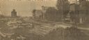
| Date: | 1860 |
|---|---|
| Description: | View of the Rock River with a train on a railroad bridge in the foreground, and the town in the distance. Pedestrians are walking along a path on the left ... |
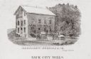
| Date: | 1880 |
|---|---|
| Description: | Exterior view of a mill, with several figures and horse-drawn vehicles located around it. Caption reads: "Sauk City Mills." |

| Date: | 1914 |
|---|---|
| Description: | Map shows school houses, creameries, post offices, saw mills, grist mills, churches, cemeteries, town halls, stores, roads, state roads, and railroads. "Co... |

| Date: | 1976 |
|---|---|
| Description: | Panel title. Shows railroads, roads, highways, boundaries, dams, public hunting and fishing grounds, cemeteries, forest ranger stations, plant life, and s... |

| Date: | 1858 |
|---|---|
| Description: | This map of Wisconsin and Minnesota shows proposed railroads, copper mines, marshes, villages, mills, reefs, notes about shorelines, and references to mini... |

| Date: | 12 1912 |
|---|---|
| Description: | Sanborn Map of Sun Prairie. The map highlights the public and parochial schools, the exhange, and church buildings, etc. |
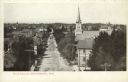
| Date: | 1908 |
|---|---|
| Description: | Elevated view looking down Main Street. A church is on the right, surrounded by dwellings obscured by trees. A mill is in the distance. Caption reads: "Mai... |
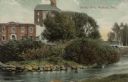
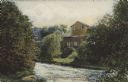
| Date: | 1911 |
|---|---|
| Description: | View from shoreline across river towards an industrial building near the Yahara River. A bridge is behind trees and bushes on the right. Caption reads: "Te... |

| Date: | 1884 |
|---|---|
| Description: | Page one of a Sanborn map of River Falls, Wisconsin. |
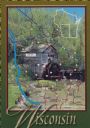
| Date: | 1988 |
|---|---|
| Description: | Text on front, at the foot: "Wisconsin." The color image of Hyde's Mill has an overlay of a map of the southwest corner of Wisconsin inside a red frame. Th... |
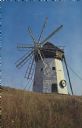
| Date: | 1950 |
|---|---|
| Description: | Text on reverse reads: "On Highway 13. Scenic Old Mill. This picturesque windmill is seen along the beautiful South Shore Drive, Hiway [number struck out w... |
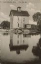
| Date: | 1910 |
|---|---|
| Description: | Text on front reads: "Waterloo, The Old Mill." A three-story mill on the bank of a millpond. |
| Date: | 1907 |
|---|---|
| Description: | Text on front reads: "Old Parfreyville Mill on Crystal River. Waupaca, Wis." A wooden mill on the banks of a river with a grass and tree covered shoreline. |
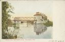
| Date: | 11 20 1906 |
|---|---|
| Description: | Text on front reads: "Bridge, Mill and Power House, Weyauwega, Wis." The Weyauwega Mill and grain elevator on the right, power house on the left with the M... |
If you didn't find the material you searched for, our Library Reference Staff can help.
Call our reference desk at 608-264-6535 or email us at:

