 Filter: Categories of Wisconsin Historical Images
Filter: FORMAT_TYPE of prints, photomechanical
Filter: Subject of grist mills
Filter: Year of 1800-1899
Filter: Categories of Wisconsin Historical Images
Filter: FORMAT_TYPE of prints, photomechanical
Filter: Subject of grist mills
Filter: Year of 1800-1899

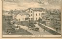
| Date: | 1860 |
|---|---|
| Description: | View of the Rock River with a train on a railroad bridge in the foreground, and the town in the distance. Pedestrians are walking along a path on the left ... |
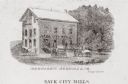
| Date: | 1880 |
|---|---|
| Description: | Exterior view of a mill, with several figures and horse-drawn vehicles located around it. Caption reads: "Sauk City Mills." |

| Date: | 1842 |
|---|---|
| Description: | Relief shown by hachures. Shows furnaces, saw mills, houses, roads, grist mills, entries, reservations, and diggings. "Compiled by order of the Board of C... |
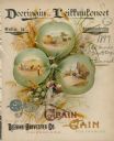
| Date: | 1897 |
|---|---|
| Description: | Finnish language catalog, featuring an illustration of an enlarged three leafed clover which is surrounded by clover flowers, wheat and a dragonfly. Small ... |

| Date: | 1858 |
|---|---|
| Description: | This map of Wisconsin and Minnesota shows proposed railroads, copper mines, marshes, villages, mills, reefs, notes about shorelines, and references to mini... |
| Date: | 1873 |
|---|---|
| Description: | A print depicts activity around the three-story, wood frame Geneva Flouring Mills. Horse-drawn wagons, pedestrians, and a boy rolling a hoop create a busy ... |

| Date: | 1884 |
|---|---|
| Description: | Page one of a Sanborn map of River Falls, Wisconsin. |
If you didn't find the material you searched for, our Library Reference Staff can help.
Call our reference desk at 608-264-6535 or email us at:
