 Filter: Categories of Wisconsin Historical Images
Filter: FORMAT_TYPE of prints, photomechanical
Filter: Subject of human settlements
Filter: Subject of buses
Filter: Categories of Wisconsin Historical Images
Filter: FORMAT_TYPE of prints, photomechanical
Filter: Subject of human settlements
Filter: Subject of buses
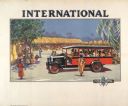
| Date: | 1929 |
|---|---|
| Description: | Advertising poster for International trucks showing color illustration of a bus or passenger truck in an African village setting. Printed for distribution ... |
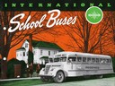
| Date: | 1940 |
|---|---|
| Description: | Front cover of an advertising brochure for International school buses. Cover features a photographic illustration of school children boarding a bus for the... |

| Date: | 1972 |
|---|---|
| Description: | Cover of a brochure advertising International school buses. Features a boy and a girl boarding a school bus. The headline reads: "Route Matched." |

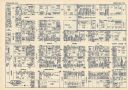
| Date: | 1935 |
|---|---|
| Description: | Page in "International Trail" magazine displaying six photographs of International vehicles in use in Brazil. They are, clockwise from top left: Model C-50... |

| Date: | 1931 |
|---|---|
| Description: | This map is an advertisement for Milwaukee street cars and motor buses and reads: "Ride the street car or motor bus. Economical, safe, dependable." Include... |

| Date: | 1964 |
|---|---|
| Description: | Shows local streets, bus routes, highways, airport, Dells Pond, Half Moon Lake, Chippewa River, and Eau Claire River. Includes 2 inset maps: Location map a... |

| Date: | 1934 |
|---|---|
| Description: | This map includes a street index. The map is oriented with the north toward the upper right. Includes handwritten annotations of the 1935 bus routes. |

| Date: | 1948 |
|---|---|
| Description: | This map of Milwaukee and surrounding suburbs includes an index to the orange bus, rapid transit, street car, trackless trolley, and the green bus lines. T... |

| Date: | 1936 |
|---|---|
| Description: | Street map of the City of Milwaukee and surrounding suburbs indicating various mass transit lines. There is an index to Milwaukee streets at the right of t... |
| Date: | 1930 |
|---|---|
| Description: | This map shows local streets, blocks, lots, local businesses by name, and bus stops. On the back of the map is text, illustrations, and aerial views. |

| Date: | 1931 |
|---|---|
| Description: | This map shows streets and highways, street car and bus lines, railroads, depots, schools, wards, and points of interest. The map is oriented with the nort... |
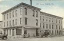
| Date: | 08 06 1919 |
|---|---|
| Description: | View from street looking towards the Hotel Higbee. There is a horse-drawn carriage on the left side, and a large, motorized vehicle, perhaps a bus, parked ... |

| Date: | 1927 |
|---|---|
| Description: | This map shows street car lines, bus routes, railroads, proposed city boundary lines, wards, public schools, blocks & house numbers, Lake Michigan, one mil... |

| Date: | 1927 |
|---|---|
| Description: | This map shows highways, roads, a proposed annexation, street car lines, bus routes, local motor bus lines, a new high speed interurban, railroads, a propo... |

| Date: | 1930 |
|---|---|
| Description: | This map shows streets, railways, bus lines, railroads, roads, parks, cemeteries, Lake Michigan, and a proposed harbor. Also included is a legend and on th... |

| Date: | 2004 |
|---|---|
| Description: | This map shows ATMs, houses of worship, hotels, parking ramps, public parking, union cab stands, bus stops, business district, parks and public areas, gove... |
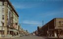
| Date: | 1951 |
|---|---|
| Description: | Colorized postcard view down a street in a main shopping district. Traffic signals are on the corners, and a large flag is hanging from the Beaumont Hotel ... |
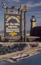
| Date: | 1973 |
|---|---|
| Description: | Text on sign reads: "Lighthouse on the Lake, Motel, Restaurant, Indoor Pool." On reverse: "Lighthouse Inn on the Lake. Highway 42, 1515 Memorial Drive, Two... |
If you didn't find the material you searched for, our Library Reference Staff can help.
Call our reference desk at 608-264-6535 or email us at: