 Filter: Categories of Wisconsin Historical Images
Filter: FORMAT_TYPE of prints, photomechanical
Filter: Subject of human settlements
Filter: Subject of germans
Filter: Categories of Wisconsin Historical Images
Filter: FORMAT_TYPE of prints, photomechanical
Filter: Subject of human settlements
Filter: Subject of germans
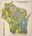
| Date: | 1940 |
|---|---|
| Description: | Map of the people of Wisconsin according to ethnic stocks. |

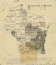
| Date: | 06 29 1941 |
|---|---|
| Description: | A map showing the national roots of the people of Wisconsin, based on the ethnic stock research by University of Wisconsin-Madison sociologist Prof. George... |
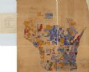
| Date: | 1918 |
|---|---|
| Description: | This map is ink on tracing paper showing all the counties of Wisconsin. The upper right hand corner contains a legend for distinguishing Wisconsin counties... |
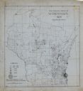
| Date: | 1890 |
|---|---|
| Description: | A hand-colored map of Wisconsin showing distribution ethnic groups based on the 1885 state census. The various nationalities are color-coded and include: I... |
| Date: | |
|---|---|
| Description: | A map indicating the population density of German-born people in Wisconsin based on the 1905 census. The map shows the county boundaries throughout the sta... |
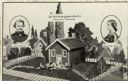
| Date: | |
|---|---|
| Description: | Artist's rendering of an elevated view of the first kindergarten, with children and a teacher gathered in front of the building. There are inset portraits ... |

| Date: | 10 1917 |
|---|---|
| Description: | Poster commissioned by the Rememberance League for an October, 1917, exhibition on German war crimes in France. Poster image shows a drawing of a German so... |
If you didn't find the material you searched for, our Library Reference Staff can help.
Call our reference desk at 608-264-6535 or email us at: