 Filter: Categories of Wisconsin Historical Images
Filter: FORMAT_TYPE of prints, photomechanical
Filter: Subject of human settlements
Filter: Subject of immigrants
Filter: Categories of Wisconsin Historical Images
Filter: FORMAT_TYPE of prints, photomechanical
Filter: Subject of human settlements
Filter: Subject of immigrants

| Date: | 1848 |
|---|---|
| Description: | Immigrant map. |
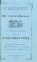
| Date: | 1879 |
|---|---|
| Description: | Blue cover design of an official report entitled "Wisconsin. What It Offers to the Immigrant". |

| Date: | 1917 |
|---|---|
| Description: | World War I poster urging newly arrived immigrants to conserve food to aid the allied cause. People in ethnic costume being ushered into the United States ... |
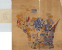
| Date: | 1890 |
|---|---|
| Description: | A hand-colored map of Wisconsin showing distribution ethnic groups based on the 1885 state census. The various nationalities are color-coded and include: I... |
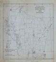
| Date: | 1905 |
|---|---|
| Description: | A map of showing the population density of foreign-born Scandinavians in Wisconsin based information from the 1905 census. The map also shows the county bo... |
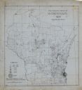
| Date: | |
|---|---|
| Description: | A map indicating the population density of German-born people in Wisconsin based on the 1905 census. The map shows the county boundaries throughout the sta... |
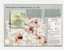
| Date: | 1998 |
|---|---|
| Description: | This map shows the number of Welsh-born heads of households around 1870. A small inset map in the lower left corner shows Welsh land ownership in the heart... |

| Date: | |
|---|---|
| Description: | Hand-colored postcard of the American Club during the time it was a dorm for immigrant workers. |
If you didn't find the material you searched for, our Library Reference Staff can help.
Call our reference desk at 608-264-6535 or email us at: