Filter: Categories of Wisconsin Historical Images
Filter: FORMAT_TYPE of prints, photomechanical
Filter: Subject of human settlements
Filter: Subject of indians of north america
Filter: Categories of Wisconsin Historical Images
Filter: FORMAT_TYPE of prints, photomechanical
Filter: Subject of human settlements
Filter: Subject of indians of north america

| Date: | 1852 |
|---|---|
| Description: | Illustration of four Indians on Madeline Island with a canoe in the water on the shore. |

| Date: | 1886 |
|---|---|
| Description: | This map shows U.S. land offices, completed railroads, railroad land grant limits, lakes, rivers, and Indian reservations. Communities, lakes, and rivers a... |

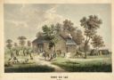
| Date: | 1910 |
|---|---|
| Description: | Sawmill on a Menominee Indian reservation, with logs floating in the water in the foreground. Caption reads: "Menominee Indian Mills." |

| Date: | 1955 |
|---|---|
| Description: | Artist's conception of ancient village of Aztalan, fortified with high walls surrounding it. |

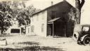
| Date: | 1837 |
|---|---|
| Description: | Fond du Lac Company House, built in 1836 and operated as an inn by Colwert Pier and his wife. Groups of Indians are in the yard outside the inn, and severa... |
| Date: | 1837 |
|---|---|
| Description: | Fond du Lac Company House. Groups of Indians are in the yard outside the inn, and several Indian dwellings are erected next to it. A man on horseback with ... |
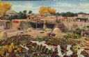
| Date: | |
|---|---|
| Description: | Santa Clara--near the town of Espanola--home of several makers of the famous Santa Clara Pottery, is one of a group of Rio Grande pueblos. |
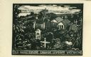
| Date: | 1959 |
|---|---|
| Description: | Caption reads: "Old Indian Burying Grounds LaPointe Wisconsin." |

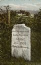
| Date: | 1905 |
|---|---|
| Description: | Indian cemetery. A large body of water is in the background. Caption reads: "Indian Burying Grounds, Bayfield, Wis." |
| Date: | 1918 |
|---|---|
| Description: | The O-Sho-Ga monument near the Indian burial grounds. Caption reads: "Apostle Islands, Wis. Madeline Island, La Pointe, O-Sho-Ga Monument near the old Indi... |

| Date: | 1877 |
|---|---|
| Description: | Map showing location of Indian reservations in the United States and population figures. |
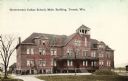
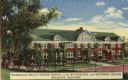
| Date: | 1912 |
|---|---|
| Description: | Exterior view of the main building. Caption reads: "Government Indian School, Main Building, Tomah, Wis." |
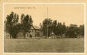
| Date: | 1910 |
|---|---|
| Description: | View across lawn toward the Indian School. Caption reads: "Indian School, Wis." |
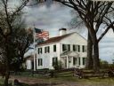
| Date: | 1905 |
|---|---|
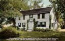
| Description: | Exterior view across yard toward the mission house. Caption reads: "Old mission house built about 1740 by Reverend John Sergeant, first missionary to the S... |
| Date: | 1940 |
|---|---|
| Description: | Winnebago Indian Mission School of the Evangelical and Reformed Church. This boarding school for Indian children was established in 1917 near Black River F... |

| Date: | |
|---|---|
| Description: | Map reads: "Historic and Scenic Wisconsin — Land of Gathering Waters." In an inset there is a hand-painted depiction of the Wisconsin State Seal. For some ... |

| Date: | 1842 |
|---|---|
| Description: | Map reads: "Wisconsin". The map depicts the counties as of 1842 and the various areas of Indian settlements. The scale is twenty miles for every inch. |
If you didn't find the material you searched for, our Library Reference Staff can help.
Call our reference desk at 608-264-6535 or email us at: