 Filter: Categories of Wisconsin Historical Images
Filter: FORMAT_TYPE of prints, photomechanical
Filter: Subject of human settlements
Filter: Subject of wells
Filter: Categories of Wisconsin Historical Images
Filter: FORMAT_TYPE of prints, photomechanical
Filter: Subject of human settlements
Filter: Subject of wells
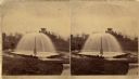
| Date: | 1876 |
|---|---|
| Description: | Stereograph of artesian well, located near the intersection of Wisconsin Street and South Minnesota Street (since renamed Wacouta). |
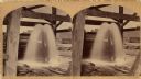
| Date: | 1875 |
|---|---|
| Description: | Stereograph of artesian well, apparently not the same one that was located near the intersection of Wisconsin Street and South Minnesota Street (since rena... |

| Date: | 1966 |
|---|---|
| Description: | The map shows streets, wells, school land, parks, cemeteries, railroads, and the Delbrook Golf Course. The bottom of the map reads: "January 11, 1962 May 2... |

| Date: | 1960 |
|---|---|
| Description: | This blue line print map shows pipes, valves, well site, and elevation tank, as well as lot and block numbers and dimensions. The map includes inset of con... |
If you didn't find the material you searched for, our Library Reference Staff can help.
Call our reference desk at 608-264-6535 or email us at: