 Filter: Categories of Wisconsin Historical Images
Filter: FORMAT_TYPE of prints, photomechanical
Filter: Subject of intellectual life
Filter: Subject of forests and forestry
Filter: Categories of Wisconsin Historical Images
Filter: FORMAT_TYPE of prints, photomechanical
Filter: Subject of intellectual life
Filter: Subject of forests and forestry

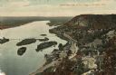
| Date: | 1883 |
|---|---|
| Description: | Bird's-eye map of Sauk City. |

| Date: | 1910 |
|---|---|
| Description: | Aerial view of some of the 26 lakes known collectively as the Chain O' Lakes. Caption reads: "Aeroplane View of Chain O'Lakes, Waupaca, Wis." |
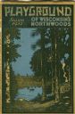
| Date: | 1931 |
|---|---|
| Description: | Cover of a Wisconsin tourism pamphlet for the 1932 season. |

| Date: | 1972 |
|---|---|
| Description: | Aerial view of commercial buildings and dwellings along the shore of Lake Michigan. Caption reads: "Baileys Harbor, Wisc." |
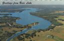
| Date: | 1967 |
|---|---|
| Description: | Aerial view of Bear Lake, with surrounding forests and farms. Caption reads: "Greetings from Bear Lake." |

| Date: | 1950 |
|---|---|
| Description: | Aerial view of town, showing all of Lake Metonga in the background. Caption reads: "Greetings from Crandon, Wisconsin." |
| Date: | 1910 |
|---|---|
| Description: | Color enhanced aerial view of the village of DeSoto, looking north along the Mississippi River. Caption reads: "Bird's Eye View of the Village of De Soto, ... |

| Date: | 1960 |
|---|---|
| Description: | Aerial view of the Trees for Tomorrow Environmental Center, with buildings, grounds, roads, and the Eagle River. Founded in 1944. |

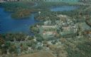
| Date: | 1950 |
|---|---|
| Description: | Aerial view of St. Bede's Priory and High School, including the surrounding country landscape. There is a highway behind the buildings. The Priory is the M... |

| Date: | 1929 |
|---|---|
| Description: | Aerial view of Lake Namakagon, showing the roads that connect Anderson Island (center left), and Juneks Point, Eagle Point, and Paines Island. |

| Date: | |
|---|---|
| Description: | Color aerial postcard view of Gordon, with the St. Croix Flowage and the St. Croix River, and surrounding forests. Caption reads: "Greetings from Gordon, W... |

| Date: | |
|---|---|
| Description: | A presidential political campaign postcard with an aerial view of Rancho Del Cielo, or "The Western White House." In the upper left corner is a head and sh... |
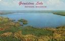
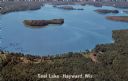
| Date: | |
|---|---|
| Description: | Aerial view of Grindstone Lake and fall foliage. Text on reverse reads: "One of Hayward's most beautiful lakes, noted for world-record muskies, and white s... |
| Date: | 1967 |
|---|---|
| Description: | Aerial view of a lake with islands surrounded by forest. Text on reverse reads: "Joined by a navigable water channel to Lost Land Lake this combined wat... |

| Date: | |
|---|---|
| Description: | Aerial view of the Pike Chain of Lakes near Iron River, Wisconsin. Caption reads: "Pike Chain of Lakes." Text on back reads: "The ideal vacationland for fi... |
| Date: | |
|---|---|
| Description: | Aerial view of the Wisconsin Veterans' Home campus beside Chain O' Lakes and the village of King. Text on reverse reads: "Founded in 1887 by The Grand A... |

| Date: | |
|---|---|
| Description: | Kodachrome postcard of an aerial view of Lac du Flambeau village and the surrounding chain of lakes. Caption reads: "Lac du Flambeau, Wisconsin." Text on b... |
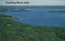
| Date: | |
|---|---|
| Description: | Aerial photograph of a lake in the Lac du Flambeau chain of lakes. Caption reads: "Crawling Stone Lake." |
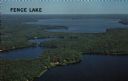
| Date: | |
|---|---|
| Description: | Aerial view of Fence Lake, one of the largest lakes in northern Wisconsin. Caption reads: "Fence Lake." |

| Date: | |
|---|---|
| Description: | Aerial view of Squaw Lake, an excellent fishing lake located on Highway 70 just south of Lac du Flambeau. Caption reads: ", Wis."Caption reads: "Squaw Lake... |
If you didn't find the material you searched for, our Library Reference Staff can help.
Call our reference desk at 608-264-6535 or email us at: