 Filter: Categories of Wisconsin Historical Images
Filter: FORMAT_TYPE of prints, photomechanical
Filter: Subject of intellectual life
Filter: Subject of peninsulas
Filter: Categories of Wisconsin Historical Images
Filter: FORMAT_TYPE of prints, photomechanical
Filter: Subject of intellectual life
Filter: Subject of peninsulas

| Date: | 1883 |
|---|---|
| Description: | Bird's-eye map of Superior, county seat of Douglas County, on the shores of Lake Superior, with insets of points of interest. |
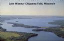
| Date: | 1950 |
|---|---|
| Description: | Color photograph of an aerial view of Lake Wissota looking east on Highway 29. Many resorts are in the area. Lake Wissota is one of the largest man-made la... |
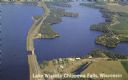
| Date: | 1950 |
|---|---|
| Description: | Aerial view, looking northwest, three miles east of Chippewa Falls, Wisconsin. Big Lake Wissota is seen across from Highway 29 in this color postcard, with... |

| Date: | 1942 |
|---|---|
| Description: | This pictorial bird's-eye-view map shows the United States of America with parts of Canada and Mexico. Landscape, trade, industry, points of interest, peop... |

| Date: | 1980 |
|---|---|
| Description: | Aerial shot directly over Picnic Point. Boats are in the lake. Text on reverse reads: "Picnic Point — A peninsula of the University of Wisconsin campus jut... |
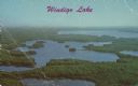
| Date: | 1964 |
|---|---|
| Description: | Text on front reads: "Windigo Lake." On reverse: "Windigo Lake. 7 miles South of Hayward, Wisc. on Hiway 27. Vacation Paradise of Northern Wisconsin." Aeri... |
If you didn't find the material you searched for, our Library Reference Staff can help.
Call our reference desk at 608-264-6535 or email us at: