 Filter: Categories of Wisconsin Historical Images
Filter: FORMAT_TYPE of prints, photomechanical
Filter: Subject of intellectual life
Filter: Subject of shipping
Filter: Categories of Wisconsin Historical Images
Filter: FORMAT_TYPE of prints, photomechanical
Filter: Subject of intellectual life
Filter: Subject of shipping

| Date: | 1890 |
|---|---|
| Description: | Bird's-eye map of Ashland, viewed from Lake Superior, with insets of Prentice Park and Fishery. Population 16,000. Increase in Ten Years, 11,000. |

| Date: | 1890 |
|---|---|
| Description: | Bird's-eye map of West Superior and Superior, with insets of Wright Farm and First Building in Superior. |

| Date: | 1910 |
|---|---|
| Description: | Elevated view of downtown. Part of the Milwaukee River is on the left side. Sign for the Germania building is in the lower right, and city hall is in the b... |
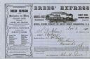
| Date: | 11 08 1860 |
|---|---|
| Description: | Receipt for a package delivered to Brees' Express via Morris & Essex Railroad. There is an engraving of a train traveling through a rural landscape near th... |

| Date: | |
|---|---|
| Description: | Memohead of the Milwaukee Dry Dock Company, which operated two docks, with a view of a dock with ships, planks of wood, buildings, and the slogan, "Electri... |

| Date: | 1952 |
|---|---|
| Description: | Map of the barley-growing regions of North America, published by the Rahr Malting Company, Manitowoc, Wisconsin, 1952. |

| Date: | 1938 |
|---|---|
| Description: | Inside spread of "At Home Abroad" brochure. The title reads: "A World-wide Sales and Service Organization." Features a map of the continents of the world. ... |
If you didn't find the material you searched for, our Library Reference Staff can help.
Call our reference desk at 608-264-6535 or email us at: