 Filter: Categories of Wisconsin Historical Images
Filter: FORMAT_TYPE of prints, photomechanical
Filter: Subject of islands
Filter: Subject of aids to navigation
Filter: Categories of Wisconsin Historical Images
Filter: FORMAT_TYPE of prints, photomechanical
Filter: Subject of islands
Filter: Subject of aids to navigation

| Date: | 1907 |
|---|---|
| Description: | A map of the eastern portion of the Apostle Islands group, and a detailed map of Gull Island showing the relief on the island, are included here, along wit... |
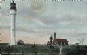
| Date: | 1913 |
|---|---|
| Description: | Hand-colored postcard showing the lighthouse and fog signal at Devil's Island in the Apostle Islands. Caption reads: "Apostle Islands, Wis. Devil's Island,... |

| Date: | 1906 |
|---|---|
| Description: | This map shows miles to other islands, harbors, canals, and passages. The South Fox ISL. LT and the Black Gas Buoy are colored in yellow and red. Depths ar... |

| Date: | 1893 |
|---|---|
| Description: | This map shows the depths of the East Neebish Rapids and the different types of minerals that make up the floor bed. Islands and Canada West is labeled. No... |

| Date: | 1735 |
|---|---|
| Description: | Map of the Chesapeake Bay region and surrounding areas, with north oriented towards the right. A few forts, rivers, and bays are labeled, as are the region... |

| Date: | 1846 |
|---|---|
| Description: | Chart of Green Bay showing depths and locations of numerous islands at a scale of 1 inch to 2 miles. There is also a profile of the dividing ridge at Sturg... |
If you didn't find the material you searched for, our Library Reference Staff can help.
Call our reference desk at 608-264-6535 or email us at: