 Filter: Categories of Wisconsin Historical Images
Filter: FORMAT_TYPE of prints, photomechanical
Filter: Subject of islands
Filter: Subject of apostle islands
Filter: Categories of Wisconsin Historical Images
Filter: FORMAT_TYPE of prints, photomechanical
Filter: Subject of islands
Filter: Subject of apostle islands

| Date: | 1886 |
|---|---|
| Description: | Bird's-eye view of Ashland, on the shores of Lake Superior, with insets of The Apostle Islands Chequamagon Bay & Ashland, and Distances from Ashland. |

| Date: | 1886 |
|---|---|
| Description: | Bird's-eye map of Washburn on Lake Superior. There is an inset of Washburn, Chequamagon and the Apostle Islands. |

| Date: | 1905 |
|---|---|
| Description: | Camp Stella looking south toward the Bayfield County shoreline from an Apostle Island. |

| Date: | 1878 |
|---|---|
| Description: | A color map detailing Ashland and Bayfield counties, including Lake Superior and the Apostle Islands. |
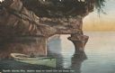
| Date: | |
|---|---|
| Description: | Postcard of the "Vessel's Stern and Rudder Post" geological formation on Madeline Island, one of the Apostle Islands. View of the shoreline and a man sitti... |

| Date: | 1884 |
|---|---|
| Description: | A detailed, hand-colored map of Wisconsin and the western portion of Michigan’s Upper Peninsula, which also includes an inset of Isle Royale in Lake Superi... |

| Date: | 1907 |
|---|---|
| Description: | A map of the eastern portion of the Apostle Islands group, and a detailed map of Gull Island showing the relief on the island, are included here, along wit... |

| Date: | 1880 |
|---|---|
| Description: | This copy of an 1834 map in the American Fur Company's papers held by the New-York Historical Society shows an outline of Chequamegon Bay and Madeline Isla... |
If you didn't find the material you searched for, our Library Reference Staff can help.
Call our reference desk at 608-264-6535 or email us at: