 Filter: Categories of Wisconsin Historical Images
Filter: FORMAT_TYPE of prints, photomechanical
Filter: Subject of islands
Filter: Subject of bays
Filter: Categories of Wisconsin Historical Images
Filter: FORMAT_TYPE of prints, photomechanical
Filter: Subject of islands
Filter: Subject of bays

| Date: | 1905 |
|---|---|
| Description: | View across field and fence downhill towards the town of Fish Creek and the bay. Caption reads: "Greetings from Fish Creek, Wis." |

| Date: | 1954 |
|---|---|
| Description: | View looking west from Eagle Bluff toward Nicolet Bay, the Strawberry Islands, and Chambers Island. Three people are sitting on the stone wall of the overl... |

| Date: | 1856 |
|---|---|
| Description: | A hand-colored map of Wisconsin, showing the county boundaries, towns, cities, railroads, roads, lakes, rivers, bays, and the Lake Superior’s islands. In ... |

| Date: | 1916 |
|---|---|
| Description: | This Wisconsin Conservation Commission map from 1916 shows Peninsula State Park in the Town of Gibraltar, Door County, Wisconsin. Depicted are open and pla... |

| Date: | 1916 |
|---|---|
| Description: | This version of a 1916 Wisconsin Conservation Commission map shows Peninsula State Park in the Town of Gibraltar, Door County, Wisconsin. Depicted are open... |

| Date: | 1836 |
|---|---|
| Description: | This map shows Havre Bay, a part of Maumee Bay, parts of Indian Island, Gard’s Island (Michigan), the Ottawa River, Vance River, creeks, and Ottawa Point (... |

| Date: | 1906 |
|---|---|
| Description: | This map shows railroads, rivers, bays, channels, shoreline and hydrography around Thunder Bay, Ontario. Depths are shown by soundings, isolines, and tints... |

| Date: | 1990 |
|---|---|
| Description: | This map shows the Minnesota Point, Wisconsin Point, Hog Island, Baker's Island, Connors Point, Blatnik Bridge, Superior Bay, Allouez Bay, the Nemadji Rive... |

| Date: | 1989 |
|---|---|
| Description: | This color coded map shows the various rivers, lakes, bays, and islands that make up the harbor. It includes an index of industries (maritime and non-marit... |

| Date: | 1891 |
|---|---|
| Description: | This map shows soft marshland, water channels, solid ground, club boundary and shooting boxes. Big Lake, First Channel, Second Channel, Fout Mile Pond, Mal... |

| Date: | 1936 |
|---|---|
| Description: | This map shows campsites, trails, auto roads, surrounding townships, and points of interest, by including pictorial illustrations. Includes an inserted map... |

| Date: | 1735 |
|---|---|
| Description: | Map of the Chesapeake Bay region and surrounding areas, with north oriented towards the right. A few forts, rivers, and bays are labeled, as are the region... |

| Date: | |
|---|---|
| Description: | Elevated view of Green Bay from Ephraim. There is an island in the bay. Caption reads: "Lake View from Scandinavian Peasant Craft Shop, Ephraim, Wis." |

| Date: | |
|---|---|
| Description: | Drawing of a map showing the cruise routes from Eagle Inn Dock and the points of interest. There is a schedule and rates on the reverse. |
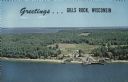
| Date: | |
|---|---|
| Description: | A color aerial view of Gills Rock from Green Bay. Washington Island and Lake Michigan are along the horizon. An excursion boat is docked at the landing. Ca... |

| Date: | 1846 |
|---|---|
| Description: | Chart of Green Bay showing depths and locations of numerous islands at a scale of 1 inch to 2 miles. There is also a profile of the dividing ridge at Sturg... |

| Date: | 1939 |
|---|---|
| Description: | Advertising proof. Features an illustration of a man driving a truck in the Court of Pacifica. Below is Treasure Island and the hills of Berkeley. |

| Date: | 1923 |
|---|---|
| Description: | Color map of the "Interborough Rapid Transit System of Greater New York". |
If you didn't find the material you searched for, our Library Reference Staff can help.
Call our reference desk at 608-264-6535 or email us at: