 Filter: Categories of Wisconsin Historical Images
Filter: FORMAT_TYPE of prints, photomechanical
Filter: Subject of islands
Filter: Subject of harbors
Filter: Categories of Wisconsin Historical Images
Filter: FORMAT_TYPE of prints, photomechanical
Filter: Subject of islands
Filter: Subject of harbors

| Date: | 1886 |
|---|---|
| Description: | Bird's-eye view of Ashland, on the shores of Lake Superior, with insets of The Apostle Islands Chequamagon Bay & Ashland, and Distances from Ashland. |

| Date: | 1910 |
|---|---|
| Description: | Bird's-eye view looking east, with Washburn Harbor at center and Chequamegon Bay in Lake Superior covering most of the upper image. Streets with buildings... |

| Date: | 1892 |
|---|---|
| Description: | Bird's-eye view of the Columbian Exposition pavilions from the vantage point of Lake Michigan. Included is an inset of the Union Passenger Station (now Uni... |
| Date: | 1910 |
|---|---|
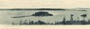
| Description: | View of Sawyer Harbor as seen from Government Bluff. |

| Date: | 1935 |
|---|---|
| Description: | An International C-55 truck works to build a breakwater at Port Allen on the island of Kauai. |

| Date: | 1916 |
|---|---|
| Description: | This Wisconsin Conservation Commission map from 1916 shows Peninsula State Park in the Town of Gibraltar, Door County, Wisconsin. Depicted are open and pla... |

| Date: | 1916 |
|---|---|
| Description: | This version of a 1916 Wisconsin Conservation Commission map shows Peninsula State Park in the Town of Gibraltar, Door County, Wisconsin. Depicted are open... |

| Date: | 1989 |
|---|---|
| Description: | This color coded map shows the various rivers, lakes, bays, and islands that make up the harbor. It includes an index of industries (maritime and non-marit... |

| Date: | 1936 |
|---|---|
| Description: | This map shows campsites, trails, auto roads, surrounding townships, and points of interest, by including pictorial illustrations. Includes an inserted map... |
| Date: | |
|---|---|
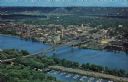
| Description: | Photographic postcard of an aerial view over La Crosse and the I-90 Interstate bridge. French Island is in the foreground. |

| Date: | 1853 |
|---|---|
| Description: | A map of Wellfleet Harbor on Cape Cod Bay. |

| Date: | 1910 |
|---|---|
| Description: | Sanborn insurance map of Milwaukee showing a portion of Jones Island with Lake Michigan at the top and the Milwaukee River at the bottom. |

| Date: | 1814 |
|---|---|
| Description: | A map of the Harbour (sic) of St. Catherine (Brazil). |
If you didn't find the material you searched for, our Library Reference Staff can help.
Call our reference desk at 608-264-6535 or email us at: