 Filter: Categories of Wisconsin Historical Images
Filter: FORMAT_TYPE of prints, photomechanical
Filter: Subject of islands
Filter: Subject of shorelines
Filter: Categories of Wisconsin Historical Images
Filter: FORMAT_TYPE of prints, photomechanical
Filter: Subject of islands
Filter: Subject of shorelines

| Date: | 1886 |
|---|---|
| Description: | Bird's-eye map of Washburn on Lake Superior. There is an inset of Washburn, Chequamagon and the Apostle Islands. |

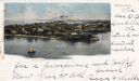
| Date: | 1905 |
|---|---|
| Description: | View across field and fence downhill towards the town of Fish Creek and the bay. Caption reads: "Greetings from Fish Creek, Wis." |
| Date: | 1884 |
|---|---|
| Description: | Illustration of the Falls of St. Anthony, as seen in The Indian Tribes of the United States: their history antiquities, customs, religion, arts, languag... |
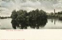
| Date: | 1900 |
|---|---|
| Description: | View across water towards Tivoli Island. There is a smokestack and a building among trees in the distance. Caption reads: "Tivoli Island, Watertown, Wis." |
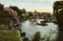
| Date: | 1905 |
|---|---|
| Description: | View from shoreline towards a river with a dam in the distance. Caption reads: "River Scene, Mayville, Wis." |
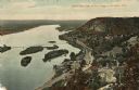
| Date: | 1902 |
|---|---|
| Description: | Elevated view of island with houses and boathouses and boats along the shoreline. Industrial buildings are in the background, and a sailboat is on the wate... |

| Date: | 04 1971 |
|---|---|
| Description: | Poster featuring a stylized sun rising over the ocean, advertising spring break vacations to Nassau for University of Wisconsin faculty and students. |
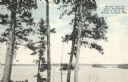
| Date: | |
|---|---|
| Description: | Colorized postcard of Boulder Lake. Pine trees are in the foreground and islands are below in the background. Caption reads: "Boulder Lake at Camp Manitowi... |

| Date: | 07 31 1909 |
|---|---|
| Description: | Photographic postcard of elevated view of the city and the Mississippi River. Homes and business are visible along 2nd Street. Caption reads: "Alma, WI." |
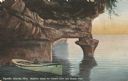
| Date: | |
|---|---|
| Description: | Postcard of the "Vessel's Stern and Rudder Post" geological formation on Madeline Island, one of the Apostle Islands. View of the shoreline and a man sitti... |

| Date: | |
|---|---|
| Description: | The top elevated view shows the Wisconsin River with several boats. The bottom view includes the river and the Northwestern Railroad bridge from the shorel... |
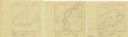
| Date: | 1939 |
|---|---|
| Description: | A survey map of Island Lake in Bayfield County, Wisconsin, Chain Lake in Rusk and Chippewa counties, and Manson Lake in Oneida County. The maps show the de... |

| Date: | 1862 |
|---|---|
| Description: | This map of the Mississippi River between Island No. 8, northeast of New Madrid, Missouri, and Tiptonville, Tennessee, depicts the Confederate defenses at ... |
| Date: | 1910 |
|---|---|
| Description: | Color enhanced aerial view of the village of DeSoto, looking north along the Mississippi River. Caption reads: "Bird's Eye View of the Village of De Soto, ... |

| Date: | 1902 |
|---|---|
| Description: | This map is a chart of Milwaukee Harbor that displays local streets, bridges, roads, railroads, public buildings, businesses, factories, dry docks, parks, ... |

| Date: | 1906 |
|---|---|
| Description: | This map shows railroads, rivers, bays, channels, shoreline and hydrography around Thunder Bay, Ontario. Depths are shown by soundings, isolines, and tints... |

| Date: | 1990 |
|---|---|
| Description: | This map shows the Minnesota Point, Wisconsin Point, Hog Island, Baker's Island, Connors Point, Blatnik Bridge, Superior Bay, Allouez Bay, the Nemadji Rive... |

| Date: | 1929 |
|---|---|
| Description: | Aerial view of Lake Namakagon, showing the roads that connect Anderson Island (center left), and Juneks Point, Eagle Point, and Paines Island. |

| Date: | |
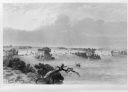
|---|---|
| Description: | Illustration of Fort Armstrong on Rock Island, looking from opposite shoreline. There is a barge and other boats on the Mississippi River in front of the f... |
| Date: | |
|---|---|
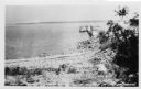
| Description: | View from shoreline towards a boat docked at a pier at Death's Door, with Plum Island in the distance. |
If you didn't find the material you searched for, our Library Reference Staff can help.
Call our reference desk at 608-264-6535 or email us at: