 Filter: Categories of Wisconsin Historical Images
Filter: FORMAT_TYPE of prints, photomechanical
Filter: Subject of islands
Filter: Categories of Wisconsin Historical Images
Filter: FORMAT_TYPE of prints, photomechanical
Filter: Subject of islands

| Date: | 1893 |
|---|---|
| Description: | This map shows the depths of the East Neebish Rapids and the different types of minerals that make up the floor bed. Islands and Canada West is labeled. No... |

| Date: | 1906 |
|---|---|
| Description: | This map shows railroads, rivers, bays, channels, shoreline and hydrography around Thunder Bay, Ontario. Depths are shown by soundings, isolines, and tints... |

| Date: | 1910 |
|---|---|
| Description: | This map shows shoreline lot numbers and acreages, the Wisconsin River, and the Michigan and Wisconsin state line. Manuscript annotations relating to topon... |
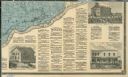
| Date: | 1878 |
|---|---|
| Description: | The bottom right corner of a map of Crawford County. This portion of the map includes town directories and illustrations of the Court House in Prairie Du C... |

| Date: | 1959 |
|---|---|
| Description: | This map includes directories, illustrations, and an inset location map and also covers Rock, Hog, Detroit and Plum islands. |

| Date: | 1891 |
|---|---|
| Description: | This blueprint manuscript map shows land owned by Kaukauna Water Power Co., Green Bay & Mississippi Canal Co., A.W. Patten, N.M. Edwards, and M.J. Meade. P... |

| Date: | 1857 |
|---|---|
| Description: | This map shows lot and block numbers, streets, railroad depots, locks, bridges, dams, canals, U.S. light house, college grounds, a steam boat landing, and ... |

| Date: | 1990 |
|---|---|
| Description: | This map shows the Minnesota Point, Wisconsin Point, Hog Island, Baker's Island, Connors Point, Blatnik Bridge, Superior Bay, Allouez Bay, the Nemadji Rive... |

| Date: | 1989 |
|---|---|
| Description: | This color coded map shows the various rivers, lakes, bays, and islands that make up the harbor. It includes an index of industries (maritime and non-marit... |

| Date: | 1920 |
|---|---|
| Description: | This map shows a small island in the Menominee River and includes a survey table and certification. |

| Date: | 1891 |
|---|---|
| Description: | This map shows soft marshland, water channels, solid ground, club boundary and shooting boxes. Big Lake, First Channel, Second Channel, Fout Mile Pond, Mal... |

| Date: | 1891 |
|---|---|
| Description: | This map shows soft marshland, water channels, solid ground, club boundary and shooting boxes. Big Lake, First Channel, Second Channel, Fout Mile Pond, Mal... |

| Date: | 1912 |
|---|---|
| Description: | Marinette County, Fract. Township 36 N., Ranges 21 and 22 E. |

| Date: | 1912 |
|---|---|
| Description: | Marinette County, Fract. Township 37 N., Ranges 21 and 22 E. |

| Date: | 1936 |
|---|---|
| Description: | This map shows campsites, trails, auto roads, surrounding townships, and points of interest, by including pictorial illustrations. Includes an inserted map... |

| Date: | 1929 |
|---|---|
| Description: | Aerial view of Lake Namakagon, showing the roads that connect Anderson Island (center left), and Juneks Point, Eagle Point, and Paines Island. |

| Date: | 1907 |
|---|---|
| Description: | Hand-colored view across water towards three islands in big Cedar Lake. The center island has a resort building with a red roof. |

| Date: | |
|---|---|
| Description: | Photographic postcard of two images: the one on the left is titled: "A Sample Catch" and is of three men holding the fish they caught, with a dog sitting a... |

| Date: | |
|---|---|
| Description: | Illustration of Fort Armstrong on Rock Island, looking from opposite shoreline. There is a barge and other boats on the Mississippi River in front of the f... |

| Date: | 1871 |
|---|---|
| Description: | A map of California showing railroad lines and reservations. |
If you didn't find the material you searched for, our Library Reference Staff can help.
Call our reference desk at 608-264-6535 or email us at: