 Filter: Categories of Wisconsin Historical Images
Filter: FORMAT_TYPE of prints, photomechanical
Filter: Subject of islands
Filter: Categories of Wisconsin Historical Images
Filter: FORMAT_TYPE of prints, photomechanical
Filter: Subject of islands
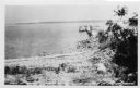
| Date: | |
|---|---|
| Description: | View from shoreline towards a boat docked at a pier at Death's Door, with Plum Island in the distance. |

| Date: | 1735 |
|---|---|
| Description: | Map of the Chesapeake Bay region and surrounding areas, with north oriented towards the right. A few forts, rivers, and bays are labeled, as are the region... |

| Date: | 1793 |
|---|---|
| Description: | Detailed topographical map of the Ohio River between Clarkville and Louisville. It shows plots of farmland, forest, islands, garden plots, houses, Fort Fe... |

| Date: | 1755 |
|---|---|
| Description: | Map of the Great Lakes region during the French and Indian War. It shows in great detail the territories, borders and boundary lines, Native American tribe... |

| Date: | |
|---|---|
| Description: | Elevated view of Green Bay from Ephraim. There is an island in the bay. Caption reads: "Lake View from Scandinavian Peasant Craft Shop, Ephraim, Wis." |

| Date: | |
|---|---|
| Description: | Drawing of a map showing the cruise routes from Eagle Inn Dock and the points of interest. There is a schedule and rates on the reverse. |

| Date: | 1913 |
|---|---|
| Description: | View across water towards Elmwood Island, with lakeside homes. Caption reads: "Elmwood Island at Fox Lake, Wis." |
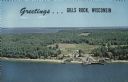
| Date: | |
|---|---|
| Description: | A color aerial view of Gills Rock from Green Bay. Washington Island and Lake Michigan are along the horizon. An excursion boat is docked at the landing. Ca... |
| Date: | |
|---|---|
| Description: | A detailed blueprint map showing the route of Howard Greene and The Gang's canoe trip through the Rainy Lake region in 1910. |
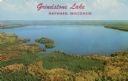
| Date: | |
|---|---|
| Description: | Aerial view of Grindstone Lake and fall foliage. Text on reverse reads: "One of Hayward's most beautiful lakes, noted for world-record muskies, and white s... |
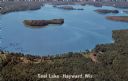
| Date: | 1967 |
|---|---|
| Description: | Aerial view of a lake with islands surrounded by forest. Text on reverse reads: "Joined by a navigable water channel to Lost Land Lake this combined wat... |

| Date: | |
|---|---|
| Description: | A bathing beach on an island near a bridge, with people in the water and on the beach within an enclosed area. A canoe and rowboat are pulled up on the sho... |
| Date: | 1951 |
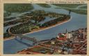
|---|---|
| Description: | Aerial view of a highway bridge crossing the Mississippi River and French Island. Caption reads: "New Bridge over Mississippi River, La Crosse, Wis." |
| Date: | |
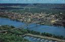
|---|---|
| Description: | Photographic postcard of an aerial view over La Crosse and the I-90 Interstate bridge. French Island is in the foreground. |

| Date: | |
|---|---|
| Description: | Hand-colored view of the entrance to Oehler's Cave. A group of people are gathered on an island in the stream at the mouth of the cave. Caption reads: "Oeh... |
| Date: | |
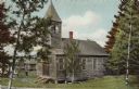
|---|---|
| Description: | View of a small wooden church among birch trees. Other buildings are in the background on the left. |
| Date: | |
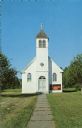
|---|---|
| Description: | View down sidewalk towards the front of a small wooden church. Text on back reads: "Franciscan Fathers, Madeline Island." |
| Date: | |
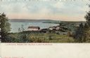
|---|---|
| Description: | Hand-colored view of a small community on the shore of Lake Superior. |

| Date: | |
|---|---|
| Description: | Text on reverse reads: "Chateau Madeleine La Pointe, Wisconsin Summer and Fall Resort on Madeline Island (Apostle Islands) in Lake Superior. The Chateau's... |

| Date: | |
|---|---|
| Description: | Kodachrome postcard of an aerial view of Lac du Flambeau village and the surrounding chain of lakes. Caption reads: "Lac du Flambeau, Wisconsin." Text on b... |
If you didn't find the material you searched for, our Library Reference Staff can help.
Call our reference desk at 608-264-6535 or email us at: