 Filter: Categories of Wisconsin Historical Images
Filter: FORMAT_TYPE of prints, photomechanical
Filter: Subject of lakes
Filter: County of Milwaukee
Filter: Categories of Wisconsin Historical Images
Filter: FORMAT_TYPE of prints, photomechanical
Filter: Subject of lakes
Filter: County of Milwaukee

| Date: | 1856 |
|---|---|
| Description: | View looking west from Lake Michigan with several steam ships and sailing vessels in harbor. There is a lighthouse to left of center, along shoreline. |

| Date: | 1898 |
|---|---|
| Description: | Bird's-eye map, looking west from shoreline on Lake Michigan of Milwaukee to Golden Lake in Waukesha County, with Kenosha and Fox Point at bottom corners, ... |

| Date: | 1937 |
|---|---|
| Description: | Bird's-eye view of Milwaukee in 1853 details building features and city layout from southwest. Important buildings are numbered in a silhouette drawing bel... |

| Date: | 1882 |
|---|---|
| Description: | This basic reference map of the state shows natural features, railroads, county seats, and political boundaries against the G.L.O. township and range grid.... |

| Date: | 1908 |
|---|---|
| Description: | Colored map in perspective indicates railroad routes. Lake Winnebago and Oshkosh in center, area extends to Shawano (top right corner), Green Bay (bottom r... |

| Date: | 1895 |
|---|---|
| Description: | Panoramic view of Milwaukee looking northeast. City Hall is visible at the left and Lake Michigan can be seen at the upper right. |
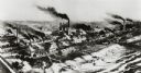
| Date: | 1892 |
|---|---|
| Description: | Milwaukee works. Long steel mill located on the bank of either a lake or a river. Multitudes of smokestacks, tracks, and small buildings. |

| Date: | 1905 |
|---|---|
| Description: | A boat with five people are on a lake surrounded by trees. Behind them are several docked boats. In the background is a park area with a red-roofed buildin... |
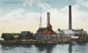
| Date: | 1911 |
|---|---|
| Description: | View across water toward several buildings on shoreline, two with large smokestacks. A man is standing on the shore, and two people are in a boat on the ri... |
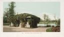
| Date: | |
|---|---|
| Description: | Small building covered with vines on the roof and sides on a path near the lake. Caption reads: "Mitchell Park, Milwaukee, Wis." |

| Date: | 1905 |
|---|---|
| Description: | Lake near the home, probably Lake Hincks, which was named after General Edward W. Hincks who was administrator of the Home in the 1870's. The grounds consi... |

| Date: | 1876 |
|---|---|
| Description: | Map of home and land, with the roads, lakes, railroad, and buildings. |
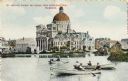
| Date: | |
|---|---|
| Description: | St. Josephat Church and School from Kosciuszko Park. The classic style church with dome is across a body of water. Three boats with boaters are out rowing ... |

| Date: | 1912 |
|---|---|
| Description: | Church and school seen from Kosciuszko Park. Located across a lake, behind some trees and bushes. A woman is sitting on some decorative stones next to the ... |
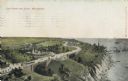
| Date: | |
|---|---|
| Description: | Elevated view with the lake on the right, with a number of boats near the shoreline. There is a long winding road through the park, including bridges, a fo... |

| Date: | 1836 |
|---|---|
| Description: | This hand-colored manuscript map shows the township and section grid in southeastern Wisconsin, covering the area west to Sugar River and Four Lakes region... |

| Date: | 05 1846 |
|---|---|
| Description: | Hand-colored map of southeastern Wisconsin showing the counties of Dodge, Jefferson, Rock, Walworth, Racine (including modern-day Kenosha County), Waukesha... |

| Date: | 1976 |
|---|---|
| Description: | An 1876 reprinted map of the Township of Franklin, Milwaukee County, Wisconsin, that shows the land ownership and sectioning of the town, as well as the ro... |

| Date: | 1886 |
|---|---|
| Description: | A hand-colored map of Milwaukee County, Wisconsin that shows the township and range system, sections, towns, roads, railroads and rail stations, cities and... |

| Date: | 1891 |
|---|---|
| Description: | A hand-colored map of Milwaukee County, Wisconsin that shows the township and range system, sections, towns, roads, railroads and rail stations, cities and... |
If you didn't find the material you searched for, our Library Reference Staff can help.
Call our reference desk at 608-264-6535 or email us at: