 Filter: Categories of Wisconsin Historical Images
Filter: FORMAT_TYPE of prints, photomechanical
Filter: Subject of lakes
Filter: County of Waukesha
Filter: Categories of Wisconsin Historical Images
Filter: FORMAT_TYPE of prints, photomechanical
Filter: Subject of lakes
Filter: County of Waukesha

| Date: | 1885 |
|---|---|
| Description: | Bird's-eye map of Oconomowoc. |

| Date: | 1870 |
|---|---|
| Description: | Birds-eye drawing of Oconomowoc depicts street names and street layouts, houses, trees, Oconomowoc River, Fowler Lake, and La Belle Lake. A reference key a... |

| Date: | 1890 |
|---|---|
| Description: | Colored bird's-eye map of Oconomowoc and the Lake Region, Waukesha County. Looking North from Government Hill. Location key below image identifies 24 Hotel... |

| Date: | |
|---|---|
| Description: | Waldheim Park Sanatorium boat house. Caption reads: "Boat House, Waldheim Park Sanatorium, Oconomowoc, Wis." |
| Date: | 1908 |
|---|---|
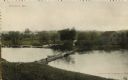
| Description: | Elevated view of lake and and a bridge road. A man is standing on the road, and a boat is pulled up near the bridge. There is a building on the opposite sh... |
| Date: | 1908 |
|---|---|
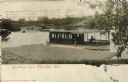
| Description: | View from shoreline towards a man on a boat on lake, and a bridge road in the background on the left. Caption reads: "Greetings from Okauchee, Wis." |
| Date: | 1913 |
|---|---|
| Description: | Ice House Bay and the lake. A man and a dog are standing on dock in the foreground, and on the right is a man in rowboat. There is a large building on the... |

| Date: | 1924 |
|---|---|
| Description: | Label submitted to the state of Wisconsin for trademark registration. "Blatz Waukesha Water, Bottled at the Springs, Waukesha WI, A natural spring water, s... |

| Date: | |
|---|---|
| Description: | This 19th century manuscript map of the Town of Oconomoc, Waukesha County, Wisconsin, is drawn on a printed township grid. It shows landownership and lakes... |

| Date: | 1873 |
|---|---|
| Description: | This late 19th century map shows the lake region around Oconomowoc in Waukesha County and eastern Jefferson County, Wisconsin. The township and range grid,... |

| Date: | 1934 |
|---|---|
| Description: | This map of Waukesha County, Wisconsin, from the Wisconsin Land Inventory shows the township and range grid, sections, cities and villages, vegetation type... |

| Date: | 1891 |
|---|---|
| Description: | This late 19th century map shows the lake region around Oconomowoc in Waukesha County and eastern Jefferson County, Wisconsin. The township and range grid,... |

| Date: | 1887 |
|---|---|
| Description: | This late 19th century map shows the lake region around Oconomowoc in Waukesha County and eastern Jefferson County, Wisconsin. Cities and villages, roads, ... |

| Date: | 1930 |
|---|---|
| Description: | This map of Waukesha County, Wisconsin, from the 1930s shows the township and range grid, towns, sections, cities and villages, highways and roads, railroa... |

| Date: | 1896 |
|---|---|
| Description: | Map shows landownership and acreages, roads, and townships. |

| Date: | 1840 |
|---|---|
| Description: | This manuscript map by Increase Lapham shows the railroads, roads, wetlands, lakes and streams, dams, prairies, and settlers in the eastern half of Waukesh... |
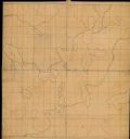
| Date: | |
|---|---|
| Description: | This manuscript map by Increase Lapham shows the lakes and streams in the northwestern quarter of Waukesha County, Wisconsin. |

| Date: | 1911 |
|---|---|
| Description: | This 1911 map from the U.S. Post Office Dept. shows rural delivery routes, active and discontinued post offices, selected rural landowners and houses, chur... |

| Date: | 1898 |
|---|---|
| Description: | Map showing the contour depths of the lakes in northwestern Waukesha County, Wisconsin. Roads, railroads, depots, churches, schools, and hotels in the area... |
If you didn't find the material you searched for, our Library Reference Staff can help.
Call our reference desk at 608-264-6535 or email us at:
