 Filter: Categories of Wisconsin Historical Images
Filter: FORMAT_TYPE of prints, photomechanical
Filter: Subject of lakes
Filter: Subject of automobiles
Filter: Categories of Wisconsin Historical Images
Filter: FORMAT_TYPE of prints, photomechanical
Filter: Subject of lakes
Filter: Subject of automobiles

| Date: | 1934 |
|---|---|
| Description: | Tourist camp at Lakeside Park on Lake Winnebago. |
| Date: | 1915 |
|---|---|
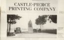
| Description: | Advertisement with the Carl Schurz monument. Caption reads: "Castle-Pierce Printing Company, Aug. 1915", and at bottom: "Oshkosh, Wisconsin". Text on right... |
| Date: | |
|---|---|
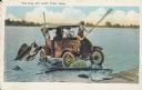
| Description: | Three men in a old-fashioned car are driving in a lake and trying to catch two giant fish near the shore. One of the men drives while the other two are try... |

| Date: | 1932 |
|---|---|
| Description: | This map includes a distance table, text, and insets maps of, Superior, Ashland, Marinette, Green Bay, Appleton, Manitowoc, Oshkosh, Fond Du Lac, Janesvill... |
| Date: | 1963 |
|---|---|
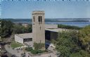
| Description: | Elevated view of the Carillon Tower and Social Science Building, on the University of Wisconsin-Madison campus. Picnic Point and Lake Mendota are in the ba... |

| Date: | 1930 |
|---|---|
| Description: | The back of the pictorial map titled Recreational Map of Glacier National Park, Montana: Waterton Lakes National Park, Alberta. 14 panels of text and photo... |
| Date: | 1936 |
|---|---|
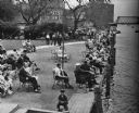
| Description: | Elevated view of people in a park along the shoreline waiting for the White Bass run. |
| Date: | 07 28 1933 |
|---|---|
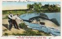
| Description: | Colorized postcard in the Tall-Tale style. Two men standing on the shore are pulling a third man's leg out of a enormous fish's mouth. Two automobiles and ... |

| Date: | 1959 |
|---|---|
| Description: | Color postcard of an aerial view of town. There is a lake in the background in the upper left. |

| Date: | |
|---|---|
| Description: | Color postcard of an aerial view of Cerami's Island View Hotel Motel Resort on the shore of Brown's Lake. |

| Date: | |
|---|---|
| Description: | Color postcard of an aerial view of the Lakewoods Family Resort on Lake Namekagon. All modern housekeeping cottages with an indoor heated swimming pool. |

| Date: | 1920 |
|---|---|
| Description: | A two-sided map of the state of Wisconsin. The front includes towns and major cities as well as state and county trunk highways. The back includes a smalle... |

| Date: | 1994 |
|---|---|
| Description: | This brochure consists of a series of 16 maps of the Military Ridge State Park Trail and the Sugar River State Trail. In all, 62 miles of bike trails and 1... |

| Date: | 1923 |
|---|---|
| Description: | This map shows trails, some in red, for automobiles. The right margin includes a key of markings as well as Minnesota and Wisconsin Highway signs. Communit... |

| Date: | 1923 |
|---|---|
| Description: | This early road map shows the system of roads in Wisconsin, northern Illinois, northeastern Iowa, southeastern Minnesota, and the western portion of Michig... |

| Date: | 1936 |
|---|---|
| Description: | This pictorial tourist map from the Wisconsin Conservation Commission depicts vacation activities and identifies tourist destinations throughout the state.... |

| Date: | 1960 |
|---|---|
| Description: | Chrome color postcard of the boat launch area. Text on back reads: "Forest County Veteran's Memorial Park located 3 miles from Crandon, WI on the south sho... |
| Date: | 1928 |
|---|---|
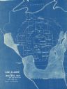
| Description: | This blue line map shows the number of carload shipments to northern and central counties, with Mosinee being the central distribution point. Lake Michigan... |

| Date: | |
|---|---|
| Description: | View across lake towards the Gonring's Resort from Cedar Lake. Along the shoreline are two buildings, a parking lot and a boat landing. Caption reads: "Gon... |
| Date: | 1909 |
|---|---|
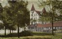
| Description: | Hand-colored view of the Lake Lawn Resort. Delavan Lake is in the background on the left. There is an automobile parked under a roofed entryway that leads ... |
If you didn't find the material you searched for, our Library Reference Staff can help.
Call our reference desk at 608-264-6535 or email us at: