 Filter: Categories of Wisconsin Historical Images
Filter: FORMAT_TYPE of prints, photomechanical
Filter: Subject of lakes
Filter: Subject of harbors
Filter: Categories of Wisconsin Historical Images
Filter: FORMAT_TYPE of prints, photomechanical
Filter: Subject of lakes
Filter: Subject of harbors

| Date: | 1913 |
|---|---|
| Description: | Bird's-eye map of Superior. "The New Steel Center." |
| Date: | |
|---|---|
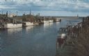
| Description: | Color photographic postcard of the fisherman's dock taken from the harbor walkway. White boats are moored on either side of the Ahnapee River as it flows i... |

| Date: | 1857 |
|---|---|
| Description: | This map of Sheboygan Harbor shows the river mouth and harbor, piers, wharfs, piles of old destroyed bridge wharfs, streets, and the lake shore from survey... |

| Date: | 1880 |
|---|---|
| Description: | Map of Wisconsin including the eastern portions on Minnesota, Iowa, northern Illinois, and the western most portion of Michigan’s Upper Peninsula, showing ... |
| Date: | 1910 |
|---|---|
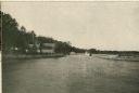
| Description: | View of the harbor at Waldwic on Lake Buttes des Morts. |

| Date: | 1909 |
|---|---|
| Description: | This map of Duluth and Superior was issued by the Duluth Street Railway Company and shows street railway routes in the cities, as well as lakes, bays, harb... |

| Date: | 1951 |
|---|---|
| Description: | This map shows Ashland and Washburn harbors in shades of blue and yellow. Water depths shown by isolines and soundings, and relief is shown by contours. Th... |

| Date: | 1951 |
|---|---|
| Description: | This map is a survey of Lake Michigan and the section of Milwaukee that borders the lake. Map of land includes major streets, and landmarks near water. Rel... |

| Date: | 1901 |
|---|---|
| Description: | This map shows streets, industrial buildings, a portion of Lake Superior and other lakes, bays, and rivers in portions of Duluth and Superior. Relief is sh... |

| Date: | 1914 |
|---|---|
| Description: | This map shows streets, industrial buildings, a portion of Lake Superior and other lakes, bays, and rivers in portions of Duluth and Superior. Relief is sh... |

| Date: | 1908 |
|---|---|
| Description: | This map shows streets, industrial buildings, a portion of Lake Superior and other lakes, bays, and rivers in portions of Duluth and Superior. Relief is sh... |

| Date: | 1905 |
|---|---|
| Description: | This map shows railroads, towns, lights, lights to be established, fog signals, light-vessels, lighted buoys, light-house depots, and light-house reservati... |

| Date: | 1923 |
|---|---|
| Description: | This map shows major cities surrounding the Great Lakes. Portions of Minnesota, Iowa, Illinois, Indiana, Ohio, Michigan, New York, Vermont, Massachusetts,C... |

| Date: | 1923 |
|---|---|
| Description: | This map includes an explanation that reads: "This chart shows the movement of oats on the Great Lakes, St. Lawrence River, and New York State Barge Canal ... |

| Date: | 1926 |
|---|---|
| Description: | This blueprint map shows the land and its uses near Two Rivers Harbor. Lake Michigan is labeled on the left. Roads and buildings are also labeled. Original... |

| Date: | 1989 |
|---|---|
| Description: | This color coded map shows the various rivers, lakes, bays, and islands that make up the harbor. It includes an index of industries (maritime and non-marit... |
| Date: | 1970 |
|---|---|
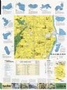
| Description: | This map includes illustrations, a location map, text, lakes fishing guide, beaches, harbor and yacht clubs, and bathymetric maps of 10 lakes: Beechwood La... |

| Date: | 1915 |
|---|---|
| Description: | Text at top reads: "Racine, Wis. View from Top of Court-House." An elevated view of Racine including the harbor. Buildings, rooftops, signs, the gas works ... |
| Date: | 1952 |
|---|---|
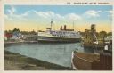
| Description: | Text on front reads: "Harbor Scene, Racine Wisconsin." A large ship is docked in Racine's harbor, with another ship and harbor facilities. |

| Date: | 1916 |
|---|---|
| Description: | Text on front reads: "North Point — Sheboygan, Wis." Elevated view of a Niagara limestone shelf of rock that rises above Lake Michigan. This rarely occurs ... |
If you didn't find the material you searched for, our Library Reference Staff can help.
Call our reference desk at 608-264-6535 or email us at: