 Filter: Categories of Wisconsin Historical Images
Filter: FORMAT_TYPE of prints, photomechanical
Filter: Subject of lakes
Filter: Subject of land use, rural
Filter: Categories of Wisconsin Historical Images
Filter: FORMAT_TYPE of prints, photomechanical
Filter: Subject of lakes
Filter: Subject of land use, rural

| Date: | 1850 |
|---|---|
| Description: | Pastoral scene depicting a small bay on the Island of St. Ignace in Lake Superior with canoes on the rocky beach, two men conversing on a blanket in the fo... |

| Date: | 1910 |
|---|---|
| Description: | Map of Dane County rural delivery in Madison and the town of Westport. |
| Date: | |
|---|---|
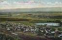
| Description: | Elevated view of Cochrane and the surrounding landscape. There are houses, railroad tracks, distant fields, a pond and some irrigation canals. Caption read... |
| Date: | 1905 |
|---|---|
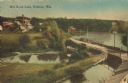
| Description: | Elevated view of a pond, a stream, and a lake, with a road dividing the pond and stream from the lake. Industrial buildings and a smokestack are in the bac... |

| Date: | 1913 |
|---|---|
| Description: | Shows lands in green owned and for sale by Homeseekers Land Company, H.J. McKusick, Secretary. Map, part colored. No scale. Photographs on reverse of origi... |
| Date: | |
|---|---|
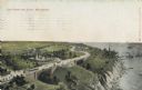
| Description: | Elevated view with the lake on the right, with a number of boats near the shoreline. There is a long winding road through the park, including bridges, a fo... |

| Date: | 1930 |
|---|---|
| Description: | Holiday card with the image of a bell. Inside is a scene of a lake with a cottage on the shore. There is a boat on the lake and a church on the opposite sh... |

| Date: | |
|---|---|
| Description: | Colorized postcard of the horseshoe curve of railroad tracks. Elevated view of the railroad tracks with train snaking past a farmhouse and a bridge suspend... |

| Date: | 1938 |
|---|---|
| Description: | "Your 1939 Calendar" published for International Harvester farm equipment dealers. The cover features a painting of the Swiss Alps. |

| Date: | 1935 |
|---|---|
| Description: | This map shows in different colors virgin timberland, second growth timber, pasture belt, crop-pasture belt, intensive crop-pasture belt, intensive pasture... |

| Date: | 1938 |
|---|---|
| Description: | This map shows "regional designation problem areas" and "nature of problem or solution." The left margin has a key showing the problem areas. The right mar... |
| Date: | 1920 |
|---|---|
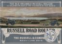
| Description: | Front cover of a booklet advertising the Russell Road Roller. The cover features an illustration of the machinery at work along a rural road and text that ... |

| Date: | 1952 |
|---|---|
| Description: | This map shows counties, towns, cities, and selected villages, as well as the Menominee Indian Reservation are identified on this U.S. Post Office. Circles... |
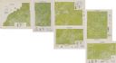
| Date: | 1975 |
|---|---|
| Description: | This series of six maps identifies land use in Taylor, Price, Rusk, Sawyer, Washburn, and Burnett counties based on data from 1966 through 1975. Each map i... |

| Date: | 1900 |
|---|---|
| Description: | This 1900 map of Walworth County, Wisconsin, shows the township and range grid, towns, sections, landownership and acreages, rural residences, cities and v... |

| Date: | 1930 |
|---|---|
| Description: | This map shows communities, state roads, county roads, railroads, lakes and rivers in the county. Areas marked in red are lands tax deeded to the county. |

| Date: | 1924 |
|---|---|
| Description: | A map of the Madison Township, T7N R9E including Lake Mendota showing the location of Ho Chunk encampments and effigy mounds. |
If you didn't find the material you searched for, our Library Reference Staff can help.
Call our reference desk at 608-264-6535 or email us at: