 Filter: Categories of Wisconsin Historical Images
Filter: FORMAT_TYPE of prints, photomechanical
Filter: Subject of lakes
Filter: Subject of university of wisconsin
Filter: Categories of Wisconsin Historical Images
Filter: FORMAT_TYPE of prints, photomechanical
Filter: Subject of lakes
Filter: Subject of university of wisconsin
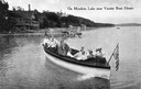
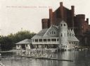
| Date: | 1915 |
|---|---|
| Description: | View of a group of people in a large model launch with an American flag. Caption reads: "On Mendota Lake near University of Wisconsin-Madison Boat House." |

| Date: | 1949 |
|---|---|
| Description: | Color bird's-eye map of the University of Wisconsin-Madison as it was midcentury, with two co-eds, several photographs of campus landmarks around edges, an... |

| Date: | 1929 |
|---|---|
| Description: | Bird's-eye map of the University of Wisconsin-Madison on Lake Mendota. Black and white drawing with named streets and numbered buildings without location ... |
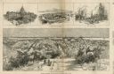
| Date: | 03 30 1889 |
|---|---|
| Description: | Bird's-eye view from Bascom Hill of Madison, with vignettes of the Wisconsin State Capitol, Lake Monona, and the Capitol Park. |

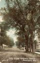
| Date: | 1905 |
|---|---|
| Description: | Parker [sic] Street, looking toward Lake Mendota. A portion of the Wisconsin Historical Society building is on the right. Caption reads: "Parker St. from U... |
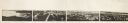
| Date: | 1870 |
|---|---|
| Description: | Panoramic view of Madison, taken from the roof of South Hall. This reduced copy was made from original negatives by E.C. Nielson. Labels for both Lake Mend... |
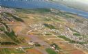
| Date: | 09 1958 |
|---|---|
| Description: | An aerial view of University Hill Farms on Madison's west side, a complete 604 acre community developed by the Regents of the University of Wisconsin. Real... |

| Date: | 1900 |
|---|---|
| Description: | A view of the city of Madison circa 1900 that was used as a letterhead. |
| Date: | 1906 |
|---|---|
| Description: | View towards shoreline from Lake Mendota of University of Wisconsin-Madison varsity men's rowing crew. People are watching from the boathouse in the backgr... |
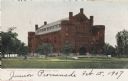
| Date: | 1907 |
|---|---|
| Description: | View across Library Mall of the University of Wisconsin-Madison Armory (Red Gym or Old Red). Lake Mendota is in the background. |

| Date: | 1930 |
|---|---|
| Description: | Boathouse on the University of Wisconsin-Madison campus. The Armory (Red Gym or Old Red) is behind the boathouse. In the left corner, a rowing ream is on t... |
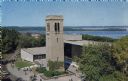
| Date: | 1963 |
|---|---|
| Description: | Elevated view of the Carillon Tower and Social Science Building, on the University of Wisconsin-Madison campus. Picnic Point and Lake Mendota are in the ba... |

| Date: | 1959 |
|---|---|
| Description: | University of Wisconsin-Madison campus. Numbers in circles identify buildings across campus with the building index. Black arrows point out important infor... |
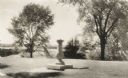
| Date: | |
|---|---|
| Description: | A sundial on a pedestal sits on Observatory Hill, overlooking trees, a rooftop, and part of Lake Mendota. |
| Date: | 1900 |
|---|---|
| Description: | Picnic Point from shoreline of Lake Mendota at the University of Wisconsin-Madison campus. There is a university building on the hill on the left, and a pi... |
| Date: | 09 14 1912 |
|---|---|
| Description: | Colorized postcard of Park[er] Street and the West End of the State Historical Library, now the headquarters building of the Wisconsin Historical Society. ... |
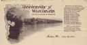
| Date: | |
|---|---|
| Description: | Letterhead of the University of Wisconsin Board of Regents, with a duotone view across Lake Mendota toward Bascom Hall, with other university buildings and... |

| Date: | 1923 |
|---|---|
| Description: | This topographical map of Devil's Lake State Park, Sauk County, Wisconsin, is based on 1922-1923 surveys of the area by the University of Wisconsin Summer ... |

| Date: | 1948 |
|---|---|
| Description: | This 1948 map shows contour and spot depths in Lake Wingra in Madison, Wisconsin. The shore outline is based on a 1940 aerial photograph. |
If you didn't find the material you searched for, our Library Reference Staff can help.
Call our reference desk at 608-264-6535 or email us at:
