 Filter: Categories of Wisconsin Historical Images
Filter: FORMAT_TYPE of prints, photomechanical
Filter: Subject of lakes
Filter: Subject of veterans
Filter: Categories of Wisconsin Historical Images
Filter: FORMAT_TYPE of prints, photomechanical
Filter: Subject of lakes
Filter: Subject of veterans

| Date: | 1795 |
|---|---|
| Description: | Detailed map of Kentucky and most of Tennessee. The map shows the borders, counties, cities, towns, Native American towns, forts, roads, mountains, lakes, ... |
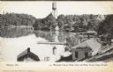
| Date: | 1907 |
|---|---|
| Description: | Text on front reads: "Waupaca, Wis. Wisconsin Veteran Home, Dock and Water Tower, Chain O'Lakes." Elevated view from hill of a man on a pier, walking towar... |
If you didn't find the material you searched for, our Library Reference Staff can help.
Call our reference desk at 608-264-6535 or email us at: